Well Drilling in Grainger County, TN
Well drilling typically runs $3,000–$16,000 nationally, per our cost guide. Independent local pros serving Rutledge, Bean Station, Blaine and nearby communities. Describe the problem and we'll route your request — free, no obligation.
- Mark no-water pump problems as emergencies on the form
- County pages on local well depths, aquifers, and permits
- Well inspections, water testing, and treatment
- Free to use — no obligation, no markup
Fast response from independent local providers. No obligation.
Typical national cost$3,000 – $16,000Cost guide →Local Help in Grainger County, TN
A U.S. Geological Survey report prepared in cooperation with Grainger County and published in 1994 (Open-File Report 93-365) states that about 75 percent of the county's residents depended on private wells for drinking water, and that wells were an important irrigation source for the county's vegetable producers. For that study, USGS sampled 35 domestic wells spread across the county in the summer of 1992.
Water wells here are built under Tennessee's Water Wells Act of 1963, as amended (T.C.A. 69-10-101 et seq.), and TDEC rule chapter 0400-45-09, Water Well Licensing Regulations and Well Construction Standards. TDEC's Knoxville Environmental Field Office lists Grainger among the counties it serves. This site passes requests along to independent contractors; it does not drill wells.
Grainger County Service Details
What providers in this area actually see: coverage, common jobs, local pricing factors, and rules worth knowing.
Service Area Notes
- Grainger County holds three incorporated places in the Census Bureau's 2020 place-by-county list: Bean Station city, Blaine city and Rutledge town. Washburn, Thorn Hill and Joppa, which are not Census places, appear in the USGS Geographic Names Information System as Grainger County populated places, and requests from them are accepted too.
- Looking up an existing well: TDEC says private water well information is public record and points owners to its Water Well Map Viewer. For a copy of the driller's report, TDEC asks owners to contact their field office with the Driller Tag number. TDEC also cautions that its database, with entries reported as far back as the 1920s, may hold records without reliable latitude and longitude.
- Checking a contractor: TDEC's licensing page says licenses are issued to individuals, not companies, cannot be transferred and expire on July 31 each year. It adds that Tennessee-licensed general contractors, electricians and plumbers may not install or maintain water wells, well pumps or well treatment systems unless they also hold the TDEC license. Under Rule 0400-45-09-.06 a licensee carries a wallet-sized license card while working, and each drill rig, water truck, pump truck and water treatment vehicle displays a TDEC decal plus the company or license holder's name on the driver's side door in bold letters at least 2 inches high. TDEC publishes a list of licensed drillers and installers.
Common Jobs in Grainger County
- New residential, farm and irrigation wells, uses that appear among the anticipated-use choices on TDEC's Notice of Intent form, CN-1240
- Pump installation and repair by a licensed pump installer; Rule 0400-45-09-.11 keeps pressure tanks above ground unless the manufacturer designates the tank for burial
- Treatment for bacteria, iron and iron-reducing bacteria, sulfur odor, hard water or sediment, which TDEC lists as common problems treatment devices may address, installed by a licensed water treatment installer
- Disinfecting the well after construction, reworking, pump installation or repairs, as Rule 0400-45-09-.12 requires
- Liner repairs: Rule 0400-45-09-.13 permits NSF-approved plastic liner casing rated at 160 psi (SDR 26), centered with guides and sealed at both ends
- Closing unused wells and filing the closure report on TDEC form CN-1241
What Drives Pricing Here
- Cost tool: the drilling estimate on this site takes your depth times a national per-foot band that shifts with rock type, plus allowances for pump, pressure tank and permit drawn from Angi, HomeGuide and HomeAdvisor cost pages. It holds no Grainger County well logs, so use the result for rough planning and get a written quote from a licensed driller.
- Depth: none of the sources cited here publishes a typical well depth for Grainger County. The 1992 USGS study started from about 500 well records in a TDEC database and kept only wells 100 to 250 feet deep yielding 10 to 50 gallons per minute, so those ranges are the study's selection rules, not county norms. TDEC says a licensed driller or a Division of Water Resources representative can help judge groundwater prospects in an area.
- State notice fee: Rule 0400-45-09-.10(1)(d) schedules the Notice of Intent fee for a water well at $75 per property site, and form CN-1240 (Rev. 04-25) shows $75.00. No notice or fee is required for well closure, deepening or reworking. The fee does not apply to an owner who filed a notice and paid the fee for the same property within the past five years, provided the new notice gives the first notice's identification number. Under paragraph (1)(e), the fee payment also does not apply to wells drilled in a local jurisdiction that is authorized by private act or a home rule charter to regulate well location and construction and has established a Commissioner-approved fee for inspecting both geothermal and water wells.
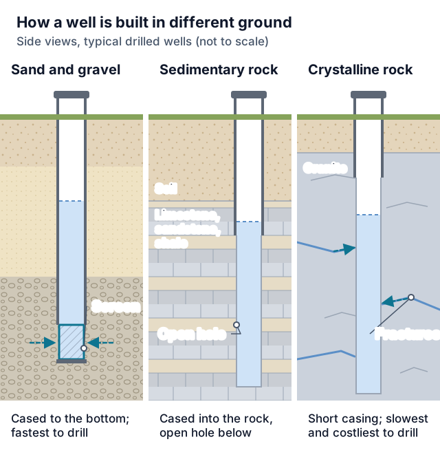
- Casing into rock: TDEC says new black or galvanized steel casing is required for a well completed in bedrock and that most wells in Middle and East Tennessee need steel casing. Rule 0400-45-09-.10(5) has casing in consolidated rock firmly seated and sealed below every crevice that releases inferior water or mud, or at least 5 feet into the top of the rock, whichever is deeper.
- Small lots: a new well may not sit closer than 10 feet to a property line, and one placed 10 to 25 feet from a line needs at least 35 feet of casing below land surface, with impervious material such as cement grout, bentonite chips or tablets, or bentonite grout backfilled in the annular space to a depth of 35 feet.
- Low yield: TDEC says a well yielding 3 to 5 gallons per minute or more will generally serve a household of four to six. Rule 0400-45-09-.10(10)(d) sets the water, setback, packer-depth, supervision and reporting conditions for fracturing a well to raise its yield, so ask how a quote handles a low-yield bore.
Permits & Local Rules
- Licensing: TDEC says anyone who conducts, manages or supervises digging, drilling, redrilling or maintenance of a well, or who installs or repairs well pumps, filters, treatment devices or geothermal closed loops, needs a license from its Division of Water Resources. Rule 0400-45-09-.06 issues driller licenses for water wells, geothermal wells, monitor wells and well closure, and installer licenses for pumps, closed loops and water treatment. An unlicensed worker may operate under a licensee only as the licensee's employee holding an installer or rig operator card, with a notarized Affidavit of Supervision on file before the work starts. TDEC's licensing page lists no owner exception for drilling or pump work; ask the Division before doing either yourself.
- Becoming licensed: Rules 0400-45-09-.02 through .06 set the age, experience, education, examination, Board of Ground Water Management interview, reciprocity and continuing-education requirements, and Rule 0400-45-09-.04 sets application and renewal fees of $100 for each driller license category and $50 for each installer category. TDEC's licensing page explains how to apply.
- Notice of Intent: the property owner or the licensed driller submits the notice to the Director of TDEC's Division of Water Resources, in the manner TDEC prescribes, before drilling starts, and the driller must hold documentation of it (the fee receipt, or a confirmation number or other format the Director approves) before beginning operations at the site. The notice expires 180 days from the date the driller or homeowner first filed it. CN-1240 also asks whether the well will serve 15 or more connections or at least 25 people for at least 60 days a year; if either answer is yes, the form says the well will likely be considered a public water system source needing TDEC approval and asks you to contact your field office before drilling.
- Separation distances, Rule 0400-45-09-.10, Table A: 200 feet from leaching pits and sewage lagoons; 100 feet from animal pens or feed lots and from sludge and septage disposal sites; 75 feet from pit privies; 50 feet from sewer lines and from septic tanks and drain fields; 10 feet from tight house-to-septic-tank and house-to-sewer lines. The rule also bars wells at other than a safe distance from any known potential contamination source, requires a well beside a building to sit where its center line, extended upward, misses every projection of the building by 5 feet or more, prohibits new wells in pits or basements, and allows a well in a flood-prone area if the top of the watertight casing extends no less than 2 feet above the 100-year flood plain.
- Source depth and casing: the water source must be at least 19 feet below ground. Where no other groundwater source is available, paragraph (3)(a)1 allows a shallower source under its own notice, casing, sealing and written-advisory conditions; ask the driller and TDEC whether that applies. Watertight casing runs from at least 19 feet below land surface to at least 6 inches above it (in an unconsolidated aquifer, at least to the top of the aquifer where that is deeper than 19 feet), unless site conditions call for the below-ground manhole design in subparagraph (5)(e). The top is capped with an approved well cap, underground lines leave through a pitless adapter that needs no welding at the casing and carries Water Systems Council PAS-1 certification or TDEC approval, and surface drainage is turned away from the wellhead.
- Grouting: the annulus from 3 to 10 feet below land surface is backfilled with cement grout or bentonite. The material must meet the cement, bentonite grout and NSF standard 60 or 61 requirements of subparagraph (6)(a). The rest of the annulus may be cement, bentonite, sand, puddled clay, well cuttings or a combination, though TDEC recommends the same grout all the way to the bottom of the casing.
- Water and disinfection: drilling water must come from a public water supply, a water well or a protected spring box (never a pond, lake or stream) and carry at least 2 ppm free chlorine. Under Rule 0400-45-09-.12, a finished, reworked or repaired well, or one that has just had a pump installed, is dosed to at least 100 ppm chlorine and agitated, the casing, pump column and other equipment above the water are rinsed with the solution, and the water stands at least 12 hours before the well is pumped until the chlorine odor is gone.
- Tag and report: before the rig leaves, the well gets a TDEC registration tag or decal, attached where it is readily visible and not removed without TDEC approval. Within 60 days after completion the driller files a Report of Well Driller (form CN-0825) with the Notice of Intent fee or a copy of its receipt. Rule 0400-45-09-.15(2) lists what the report must contain. The licensee signs the original and keeps a copy of each report and fee payment for five years. TDEC suggests owners ask the driller for a copy.
- Alternative standards: when strict compliance is impractical, the driller or installer applies to TDEC for an alternative standard before the work, and TDEC may approve one that offers equal or greater environmental protection. In an emergency or exceptional case TDEC will answer a verbal request if a written application follows within 10 days.
- Closing a well: a newly drilled well that will not be used and has no casing (or had it pulled) is backfilled and closed by the driller or a well closure license holder within 15 days after the rig leaves; until then the driller keeps the site safe, and before closing removes obstructing equipment, checks the full depth for obstructions and chlorinates the well to 25 ppm free chlorine. Rule 0400-45-09-.16 sets separate fill and seal methods for uncased wells, wells with at least 19 feet of casing, wells reaching more than one aquifer, flowing wells, hand-dug wells and obstructed older wells, and allows another method only after the Director reviews a written petition and approves it in writing before sealing; in an emergency or exceptional case TDEC will respond to a verbal request if a written application follows within 10 days. A driller or well closure license holder files a signed closure report within 60 days with the completion-report information plus how the well was closed and the placement and type of backfill, and every closure report includes a diagram giving distances in feet to one specific landmark and to the septic or sewer systems on the property.
Geology & Water Table Notes
- Mapped bedrock: USGS's state geologic map data for Grainger County list Copper Ridge Dolomite (Ordovician) at the surface over 28 % of the county, described as coarse, dark-gray knotty dolomite with abundant chert, about 1,000 feet thick. Next come the combined Maryville Limestone, Rogersville Shale and Rutledge Limestone unit (Cambrian) at 13 %, then Nolichucky Shale and Clinch Sandstone at 7 % each and the middle and lower Chickamauga Group at 6 %.
- How the water moves: USGS's Ground Water Atlas (HA 730-K) says that in the Valley and Ridge of eastern Tennessee, soluble carbonate rocks and easily eroded shales underlie the valleys while more erosion-resistant siltstone, sandstone and some cherty dolomite underlie the ridges. Groundwater is stored in and moves through fractures, bedding planes and solution openings, and within the local flow systems most of the movement takes place within 300 feet of land surface.
- Yields vary widely: HA 730-K reports yields from about 1 to 2,500 gallons per minute for wells in the principal Valley and Ridge aquifers, with median yields of about 11 to 350 gallons per minute depending on the unit. These are province-wide figures, not a forecast for one lot.
- Bacteria: in the 1992 USGS sampling, fecal coliform exceeded the state's maximum contaminant level of 0 colonies per 100 milliliters in 15 of the 35 wells, at 2 to 3,400 colonies per 100 milliliters where found, scattered across the county with no apparent clustering. The report notes that the drinking-water rules it compared against apply to public systems and are not enforceable for domestic wells.
- Iron, manganese and water type: the same study found iron above the 300 micrograms per liter secondary level in six wells and manganese above 50 micrograms per liter in seven, nitrite and nitrate below the primary limits in every well, and no organic pesticide above a primary limit (trace atrazine in wells 2, 8 and 10 and aldicarb in well 5). Calcium bicarbonate water was most common, with calcium-magnesium bicarbonate water predominating in wells in the middle-southern part of the county and sodium bicarbonate water in wells 23 and 34.
- Contamination risk: HA 730-K warns that where the residuum over the carbonate rock is thin, these aquifers are susceptible to contamination by human activities, and that natural water quality can be degraded where landfills and other waste-disposal sites, underground storage tanks and septic tank systems are located. The Tennessee Department of Health says wells in karst areas (limestone, caves, fissures) are more vulnerable because water flows quickly and carries pollutants long distances.
Communities Served
Rutledge · Bean Station · Blaine · Washburn · Thorn Hill · Joppa
Emergency Response Expectations
If floodwater has covered the top of the well casing, TDEC's private-well flood guidance warns against turning on the pump and against drinking or washing with well water that floodwater may have reached. It says the wiring should be checked by a qualified electrician or licensed pump installer before the equipment is switched back on, describes cleaning, pumping and disinfecting a drilled, driven or bored well, and does not recommend trying to disinfect or use a dug well that has flooded. We pass urgent requests to contractors but can't promise how quickly one will respond.
Grainger County FAQs
What does the state charge before a well is drilled in Grainger County?
A $75 Notice of Intent fee per property site for a water well (Rule 0400-45-09-.10 and TDEC form CN-1240). Closing, deepening or reworking a well needs no notice or fee, and an owner who already filed and paid for the same property within the past five years pays no new fee if the new notice cites the first notice's identification number. The fee payment also does not apply in a local jurisdiction that regulates wells under a private act or home rule charter and has a Commissioner-approved inspection fee for both geothermal and water wells.
How long is a Notice of Intent good for?
It expires 180 days from the original date the driller or homeowner filed it.
Can I close an old hand-dug well on my land myself?
Under Rule 0400-45-09-.16(6), a hand-dug well more than 12 inches in diameter, with no steel or plastic casing and less than 60 feet deep, may be closed by the landowner or by a Tennessee-licensed engineer, professional geologist, building contractor or pump installer, a county environmentalist or a state environmental specialist, all following the rule's hand-dug closure standards. The rule suggests the landowner contact the Division of Water Resources or a licensed driller first. Anyone other than the landowner must file the closure report; a landowner is not required to, though the rule recommends sending the Division a letter with similar information. The landowner remains responsible for the closure. Other wells are closed by a licensed driller or well closure license holder.
How deep will a new well be?
No source cited here gives a typical depth for Grainger County. Ask the driller which nearby well records they are working from; TDEC's Water Well Map Viewer provides private water well data.
Does Tennessee require testing a private well?
TDEC says the state has no requirements for sampling and analysis of private water supplies and advises asking the lender or other party requiring a test which parameters it needs. TDEC strongly recommends an annual bacteria test, and the Department of Health recommends bacteria tests every year (multiple samples), nitrates and metals every two years, volatile organic compounds every few years near industry, and radon testing if the home has elevated indoor radon. TDEC points owners to its Laboratory Certification Program page, which links lists of certified commercial and microbiological laboratories.
How far does the well have to be from my septic system?
Table A of Rule 0400-45-09-.10 sets 50 feet from septic tanks and drain fields and 10 feet from a tight house-to-septic-tank line. The driller's report records the homeowner's information or the driller's confirmation that the tank and field lines are at least 50 feet away.
Which TDEC office handles Grainger County?
TDEC's Knoxville Environmental Field Office, which lists Grainger among the counties it serves; its TDEC page has current contact details.
Sources
- Tennessee Secretary of State: Rule chapter 0400-45-09, Water Well Licensing Regulations and Well Construction Standards
- Tennessee Secretary of State: Division of Water Resources rule chapters (0400-45)
- TDEC Division of Water Resources: Well Water
- TDEC: Well Driller or Installer License
- TDEC form CN-1240: Notice of Intent to Drill Well (Rev. 04-25)
- TDEC form CN-0825: Tennessee Water Well Drillers Report
- TDEC form CN-1241: Water Well Closure Abandonment Report
- TDEC: Guidance for what to do with a water well after a flood
- TDEC: Knoxville Environmental Field Office (counties served)
- TDEC: Laboratory Certification Program
- TDEC: Water Well Map Viewer
- Tennessee Department of Health: Environmental Epidemiology Program (Private Water Supply)
- USGS Open-File Report 93-365: Ground-Water Quality for Grainger County, Tennessee (1994)
- USGS Ground Water Atlas HA 730-K: Valley and Ridge aquifers
- USGS Mineral Resources Online Spatial Data: Geologic units in Grainger County, Tennessee
- U.S. Census Bureau: Tennessee place-to-county reference file (2020)
- USGS Geographic Names Information System: Tennessee domestic names file
Last reviewed 2026-10-27
Nearby Counties
Services Available in Grainger County
Well Drilling
New residential wells — find local drillers for site evaluation, depth estimates, and written drilling quotes.
Learn more →Water Well Drilling
Household water wells from site evaluation through casing, pump, and water test — written quotes from local drillers.
Learn more →Well Pump Repair
No water at the tap? Request urgent well pump repair — local pros diagnose pressure loss, dead pumps, and pressure tank failures fast.
Learn more →Well Pump Replacement
Pump at end of life or beyond repair? Get quotes for correctly-sized submersible and jet pump replacement from local well pros.
Learn more →Well Inspection & Testing
Buying a home with a well, or overdue for a water test? Local pros for flow tests, equipment inspection, and lab water-quality testing.
Learn more →Well Water Service
Water quality problems, treatment systems, and general well maintenance — connect with local pros for everything between drilling and pump work.
Learn more →Free Tools Before You Call
Ballpark the cost or narrow down the problem before talking to a Grainger County provider.
Well Drilling Cost Calculator
Estimate what drilling a well should cost — by depth, geology, and whether you need the pump and pressure tank included.
Use the free tool →No Water From Your Well? Diagnostic Wizard
Suddenly no water in the house? Answer a few questions to find out if it's the breaker, the pressure switch, the tank, the pump — or the well itself.
Use the free tool →Well Pump Size Calculator
Find what size well pump you need — GPM demand, total dynamic head, and a horsepower recommendation from four quick inputs.
Use the free tool →Need help in Grainger County, TN?
Send the short form — urgent requests get priority routing.