Well Drilling in Tippecanoe County, IN
Well drilling typically runs $3,000–$16,000 nationally, per our cost guide. Independent local pros serving Lafayette, West Lafayette, Battle Ground and nearby communities. Describe the problem and we'll route your request — free, no obligation.
- Mark no-water pump problems as emergencies on the form
- County pages on local well depths, aquifers, and permits
- Well inspections, water testing, and treatment
- Free to use — no obligation, no markup
Fast response from independent local providers. No obligation.
Typical national cost$3,000 – $16,000Cost guide →Local Help in Tippecanoe County, IN
An April 2009 report by the Indiana DNR Division of Water on Tippecanoe County's unconsolidated aquifers says a buried bedrock valley system, the Lafayette (Teays) Bedrock Valley System, covers nearly 40 percent of the county, and that unconsolidated deposits are more than 400 feet thick in several places. Several buried valleys meet around Lafayette to form the system's main trunk, which runs 4 to 7 miles wide west of the city before leaving the county south of Otterbein, and test holes in and just outside the county indicate that its basal sand and gravel is at least 50 feet thick and in places over 150 feet.
That report maps six unconsolidated aquifer systems in the county, and its bedrock companion identifies three bedrock systems, noting that bedrock wells represent about 20 percent of all wells completed in the county. Both reports state depths and yields system by system rather than as a single county figure. Requests sent from this page are passed to independent well contractors; the site has no drilling crews of its own.
Tippecanoe County Service Details
What providers in this area actually see: coverage, common jobs, local pricing factors, and rules worth knowing.
Service Area Notes
- Requests are accepted from anywhere in the county. Places with Tippecanoe County territory, according to the Bureau of the Census file that pairs 2020 places with counties, are the cities of Lafayette and West Lafayette; the towns of Battle Ground, Clarks Hill, Dayton, Shadeland and Otterbein, the last of which is also listed under Benton County; and the census-designated places of Americus, Buck Creek, Colburn, Montmorenci, Romney, Stockwell and West Point. Each name is unchanged in the Bureau's present-day TIGERweb place layers.
- Wells near your lot: DNR's online water well record database draws on the Water Rights and Use Section's files of over 400,000 Indiana wells, roughly 138,000 of them field verified. Owner names cannot be searched, but the water well web viewer accepts a street address and ZIP code.
- Vetting a contractor: DNR posts lists of drilling and pump service contractors, and only firms with drillers and pump installers licensed for the current year appear on them. DNR says it does not recommend particular firms, and it asks anyone checking a specific driller's or pump installer's license to contact the Division of Water.
Common Jobs in Tippecanoe County
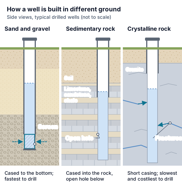
- Sand-and-gravel wells finished with a screen, which 312 IAC 13-4-2 makes standard for every well drilled into unconsolidated material except monitoring and dewatering wells
- Rock wells where the glacial cover is thin; DNR says the Till Veneer system, mapped mainly in the southwestern quarter, is commonly bypassed in favor of the underlying bedrock
- Pump swaps and repairs; apart from personal-use work and helpers a licensee directs and personally supervises, Indiana requires a DNR-licensed pump installer
- Disinfection after service or installation work, which the Tippecanoe County Health Department's bacteria page says water wells should receive
- Tracing the entry point after repeated unsatisfactory bacteria results
- Capping idle wells and plugging abandoned ones under 312 IAC 13-10
What Drives Pricing Here
- The aquifer system under the lot sets the footage. DNR's 2009 report gives typical completed depths of 60 to 100 feet in the Iroquois/Tipton Till Aquifer System, 70 to 135 feet in the Iroquois/Tipton Complex Aquifer System (80 to 180 feet where it lies over the buried valley), 60 to 105 feet in the Wabash River and Tributaries Outwash Aquifer System, and commonly 55 to 95 feet in the outwash subsystem along the Tippecanoe River, Wea Creek and Wildcat Creek. These are mapped ranges for whole systems, not a prediction for one parcel.
- About the calculator on this site: footage you enter is priced at a per-foot range for the geology you choose, then pump, pressure-tank and general permit allowances, taken from national cost pages by Angi, HomeGuide and HomeAdvisor, are added. Treat its output as a planning figure rather than a Tippecanoe County bid, and ask each driller what the quote covers.
- Casing: 312 IAC 13-4-1 sets a 2-inch minimum inside diameter for a new well's casing and, unless the division approves something else, a minimum depth of 25 feet below grade; monitoring and dewatering wells fall outside that section. For rotary and augered wells, 312 IAC 13-6-1 also has the open hole drilled at least 2 inches wider than the casing's outside diameter; that section does not cover monitoring, dewatering or public water supply wells, the last being governed by 327 IAC 8-3.4.
- Grouting: for rotary and augered wells other than monitoring, dewatering and public water supply wells, 312 IAC 13-6-1 requires at least 25 feet of the annulus to be pressure grouted with neat cement or bentonite slurry unless the division approves otherwise, and sets where the grout column starts and ends for bedrock and unconsolidated wells. Timing comes from 312 IAC 13-5-1: for any new well except a public water supply well, grout must be in the annulus no later than 24 hours after casing installation, or earlier if the drilling equipment leaves the site before then.
- Yield testing and pump depth: when a well is to get a pump, 312 IAC 13-7-1 calls for developing it and pumping it at capacity for one hour or longer while yield and drawdown are logged, then hanging the pump low enough to cover the drawdown it creates plus seasonal swings in the water level. 312 IAC 13-4-3.5 asks for pumping apparatus that leaves 20 feet or more of available drawdown in an unconsolidated aquifer and 50 feet or more in bedrock, unless the department approves otherwise. Monitoring and dewatering wells are exempt from both sections.
Permits & Local Rules
- County office: the Environmental Division of the Tippecanoe County Health Department is charged with environmental health for all of Tippecanoe County, including Lafayette and West Lafayette. It oversees permitting and inspection of residential and commercial septic systems, says every new septic system and every repair of an existing one needs its permit before construction starts, and has its staff inspect each installation on completion. It also keeps diagrams of residential and commercial septic systems installed after 1979, so ask whether one exists for your lot before picking a well site, and ask the Environmental Division before drilling about any county requirement that applies to the well itself.
- Licensing: IC 25-39-3-1 makes a DNR license mandatory for anyone working as a water well driller, defined as someone who drills or drives wells or runs the equipment that does, or as a water well pump installer, a person who installs or repairs well pumps. Licensees running a rig or setting a pump have to keep the license on them and produce it when a department representative asks. IC 25-39-1.5-3 switches off the licensing chapter and the drilling-regulation chapter (IC 25-39-3 and 25-39-4) in four situations: someone installs a personal-use well measuring 1 1/4 inches or less inside and 24 feet or less deep; a plumber holding an IC 25-28.5 license, registered with DNR as IC 25-39-1.5-4 requires, installs wells within that size and depth; someone puts in or fixes a well pump or pumping equipment for that person's own personal use; or a worker is directed and personally supervised by a licensee. Personal use, under 312 IAC 13-1-19.3, means using a well or pumping equipment to supply water, either on property that the person owns or has in possession or, for a public water supply utility, in the possession of a permanent utility employee.
- Wells outside the statute: IC 25-39-4-11 leaves three kinds out of the article altogether, namely wells drilled under, or incidental to, activities governed by IC 14-34 or IC 14-37; wells whose only purpose is supplying water for secondary petroleum recovery; and wells drilled only to test how earth materials will support bridges, roadways, buildings or other engineered structures.
- Getting licensed: IC 25-39-3-3 asks that an applicant be 18 or older, pass DNR's competency examination, which the department prepares and administers, and supply evidence from three references, two of whom are drillers, pump installers or licensed plumbing contractors who know the applicant's professional competency and work experience. A license costs $100 per calendar year under 312 IAC 13-2-2 and runs out on December 31 of its issue year (IC 25-39-3-1).
- Siting the well: for wells other than monitoring and dewatering wells, 312 IAC 13-3-2 asks the driller to take advantage of every natural protection, stay as far as practicable from high capacity wells and known contamination sources, guard against ponding, drainage and flooding, and grade earth so surface water runs away. Casing or the pitless unit has to finish 1 foot or more above the ground. Inside a designated flood hazard area, the top must also either sit 2 feet or more above the regulatory flood elevation or be closed with a watertight cap on the pitless unit, or a watertight well seal, vented to a height 2 feet or more above it. 312 IAC 13-3-3 wants 5 feet or more of clearance between any building projection and the vertical line of the well's center, plus reasonable access for cleaning, repair, testing, inspection and maintenance, and 312 IAC 13-4-4 has the division approve a well pit's design before it is built.
- Septic distances: the county's sewage disposal page links the state residential sewage disposal rule, 410 IAC 6-8.3. Table I in 410 IAC 6-8.3-57 sets 50 feet as the minimum between a private water supply well or private geothermal well and any septic tank or other treatment unit, dosing tank, lift station or soil absorption system, and 100 feet when the well is commercial, whether for water supply or geothermal use. For soil absorption systems, footnote 1 doubles these figures where some horizon in the top 34 inches has a Table IV soil loading rate higher than 0.75 gallons per day for each square foot, unless the hazard can be overcome by the system's design; footnote 2 lets the separation shrink to 10 feet from a private water supply well that has been abandoned as 312 IAC 13-10-2(e) prescribes.
- Well record: IC 25-39-4-1 and 312 IAC 13-2-6 have the driller file a record of each well with DNR within 30 days after it is completed, on a departmental or division-approved form; the rule lists every entry the record must carry. The Indiana Department of Health's recommended standards, which are guidance, say the driller should give the owner a duplicate copy of that information.
Geology & Water Table Notes
- Wabash River and Tributaries Outwash Aquifer System: DNR maps it along most of the Wabash River in the county. Its sand and gravel is commonly 50 to over 100 feet thick under a cap of silt, sandy clay or clay 5 to 20 feet thick, though in many places that cap is missing. Yields for domestic wells there are commonly 30 to 100 gallons per minute and static levels range from flowing down to 40 feet, and the system is rated highly susceptible to surface contamination where its sand and gravel lies near the surface with little or no clay.
- Outwash subsystem: along parts of the Tippecanoe River, Wea Creek and Wildcat Creek, the aquifer is generally overlain by 10 to 35 feet of silt or clay, though in many places that layer is missing, and saturated sand and gravel is commonly 20 to 40 feet thick. Domestic yields typically run 10 to 40 gallons per minute and static levels range from flowing to 25 feet below the surface.
- Iroquois/Tipton Complex Aquifer System: mapped across most of the county, with saturated sand and gravel generally 20 to 50 feet thick, domestic yields commonly 10 to 50 gallons per minute and static levels generally 30 to 70 feet down. On the high terraces along the Wabash and its major tributaries, the upper sand and gravel is typically unsaturated, and DNR says most domestic wells there use the deeper aquifers.
- Till country: DNR reports domestic well capacities commonly of 10 to 30 gallons per minute in the Iroquois/Tipton Till Aquifer System. In its subsystem, mapped mainly in the southwest quarter, about 60 percent of wells started there end up completed in the underlying bedrock. The Till Veneer system, generally 20 to 50 feet thick and mapped mainly in the southwestern quarter along Flint Creek and around Little Wea and Big Shawnee creeks, plus along the Wabash in the northeastern corner and west of Klondike around Indian Creek, has the most limited ground-water resources of the county's unconsolidated systems; most of the few wells completed in it report capacities under 10 gallons per minute.
- Bedrock: DNR describes the Borden Group, which crops out or subcrops chiefly across the southern third of the county, as mostly siltstone and shale; reported wells in it commonly reach 80 to 190 feet, a typical domestic well gives under 15 gallons per minute, and many dry holes are on record. The New Albany Shale, under a large area of central and northern Tippecanoe County, commonly yields less than 10 gallons per minute, and about half the domestic wells there drill through it to the Silurian and Devonian Carbonates. DNR adds that most bedrock aquifers in the county are confined, so the water level in most bedrock wells rises above the top of the water-bearing zone.
- Water levels: DNR's June 2015 potentiometric surface map of the county's unconsolidated aquifers contours 2,549 static water levels from well records, with groundwater flowing generally toward the Wabash and its major tributaries. Each level is a snapshot from the time its well was finished, and DNR cautions that a county map cannot stand in for a study of a specific site.
Communities Served
Lafayette · West Lafayette · Battle Ground · Clarks Hill · Dayton · Shadeland · Otterbein · Americus · Buck Creek · Colburn · Montmorenci · Romney · Stockwell · West Point
Emergency Response Expectations
Urgent requests are forwarded, but how fast an independent contractor responds is outside this site's control. The Indiana Department of Health notes wells may need sanitizing after flooding, and that bottled or filtered water can serve short term after a positive contamination test. If a test finds nitrate above 10 mg/l as nitrate-nitrogen, the county Health Department says not to give the water to infants under six months, directly or in formula, and not to boil it, since boiling raises the nitrate level.
Tippecanoe County FAQs
Who do I contact about a well permit in Tippecanoe County?
Start with the Environmental Division of the Tippecanoe County Health Department, which permits septic systems countywide, and ask whether any county approval applies to your well. Separately, state law requires the work to be done by a DNR-licensed driller unless an IC 25-39 exception applies, and a licensed driller must file the well record with DNR within 30 days after completion.
Is a homeowner allowed to drill a well or change a pump without a license?
Yes, in three cases drawn from IC 25-39-1.5-3: the well is for your personal use and is no wider than 1 1/4 inches inside and no deeper than 24 feet; you are installing or repairing pumping equipment for your own personal use; or you work under a licensee's direction and personal supervision. Personal use here means using a well or pump to supply water on property you own or have in your possession. The same section also exempts a plumber licensed under IC 25-28.5 and registered with DNR who installs wells within that 1 1/4-inch, 24-foot limit. Outside those four exemptions, the work calls for a driller or pump installer holding a DNR license, unless the well is one of the special-purpose types excluded by IC 25-39-4-11.
What distances does the state suggest from barns, manure and fuel?
The septic distances that bind are the 410 IAC 6-8.3-57 figures under the permit notes above. For other sources, the Indiana Department of Health's Recommended Standards for Private Water Wells, which are guidance rather than law, suggest that a private well serving a residence sit at least 50 feet from a stable, animal barn or feeding pen, milk house, livestock run or silo, and 100 feet from a pit privy, manure pile, manure holding tank, silage pit, dry well, seepage pit or trench, cesspool, or stored chemicals such as fuel, fertilizer and pesticides. Those figures should be at least doubled, it says, if the casing terminates under 25 feet from finished grade or the well goes through creviced or highly porous formations, and when the table cannot be met it points owners to the local health department to discuss lesser separations justified by special construction or favorable geology.
What should I test my well water for, and how often?
The county Health Department suggests starting with bacteria and total nitrate/nitrite. Its nitrate page recommends a nitrate test for every newly built private well and any well not tested in the past five years, recommends testing for wells used by pregnant women and calls it essential for wells serving infants under six months, and notes that wells shallower than 50 feet are more prone to high nitrate. Bacteria and nitrate every year, plus fluoride, arsenic, lead and copper every five years at least or whenever major maintenance is done, is the schedule the Indiana Department of Health laboratory recommends. The county's water testing page lists laboratories, among them the state health department's lab.
My well failed a bacteria test; what should happen next?
The county's bacteria page suggests submitting another sample after a first unsatisfactory result, since contamination during collection is the most frequent cause. If the second sample also fails, it says disinfecting the well should be considered; if a sample fails again after disinfection, the well should be inspected for the point where contamination enters, with help from a well driller or a plumber experienced in well problems.
What has to happen to an unused or abandoned well?
If a well sits idle for over three months without being permanently abandoned, 312 IAC 13-10-1 requires a watertight cap at or above ground, attached by welding, threading or mechanical means, and upkeep that keeps the well from becoming a contamination channel. When a well's abandonment came after December 31, 1987, the owner of the land has one year from abandonment to have a water well driller plug it (IC 25-39-4-6(b)), and 312 IAC 13-10-2 calls for impervious grouting material placed by a water well driller or pump installer, with materials and methods set out for each well type. Any well drilled after December 31, 1987 and left without casing is plugged by the driller within 72 hours after completion. Separate capping and closure routes cover wells abandoned before January 1, 1988 and wells drilled before that date and abandoned before January 1, 1994; either kind must also be plugged if it poses a hazard to human health. Written notice of the abandonment goes to the division within 30 days of finishing the plugging.
Sources
- Indiana Code 2026, IC 25-39: Water well drillers and pump installers
- 312 IAC 13: Water well drillers and water well pump installers (Indiana Administrative Code)
- 410 IAC 6-8.3-57: Separation distances, residential on-site sewage systems
- Indiana DNR: Unconsolidated aquifer systems of Tippecanoe County (April 2009)
- Indiana DNR: Bedrock aquifer systems of Tippecanoe County (April 2009)
- Indiana DNR: Potentiometric surface map, unconsolidated aquifers of Tippecanoe County (June 2015)
- Indiana DNR: Driller and pump installer licensing
- Indiana DNR: Licensed water well drilling and pump installation contractors
- Indiana DNR: Water well record database
- Indiana Department of Health: Recommended standards for private water wells
- Indiana Department of Health: Well water quality and testing
- Indiana Department of Health Laboratories: Well water
- Tippecanoe County Health Department: Environmental Division
- Tippecanoe County Health Department: Sewage disposal
- Tippecanoe County Health Department: Drinking water
- Tippecanoe County Health Department: Bacteria
- Tippecanoe County Health Department: Nitrates in drinking water
- Tippecanoe County Health Department: Water testing laboratories
- U.S. Census Bureau: 2020 places by county, Indiana
Last reviewed 2026-10-30
Nearby Counties
Services Available in Tippecanoe County
Well Drilling
New residential wells — find local drillers for site evaluation, depth estimates, and written drilling quotes.
Learn more →Water Well Drilling
Household water wells from site evaluation through casing, pump, and water test — written quotes from local drillers.
Learn more →Well Pump Repair
No water at the tap? Request urgent well pump repair — local pros diagnose pressure loss, dead pumps, and pressure tank failures fast.
Learn more →Well Pump Replacement
Pump at end of life or beyond repair? Get quotes for correctly-sized submersible and jet pump replacement from local well pros.
Learn more →Well Inspection & Testing
Buying a home with a well, or overdue for a water test? Local pros for flow tests, equipment inspection, and lab water-quality testing.
Learn more →Well Water Service
Water quality problems, treatment systems, and general well maintenance — connect with local pros for everything between drilling and pump work.
Learn more →Free Tools Before You Call
Ballpark the cost or narrow down the problem before talking to a Tippecanoe County provider.
Well Drilling Cost Calculator
Estimate what drilling a well should cost — by depth, geology, and whether you need the pump and pressure tank included.
Use the free tool →No Water From Your Well? Diagnostic Wizard
Suddenly no water in the house? Answer a few questions to find out if it's the breaker, the pressure switch, the tank, the pump — or the well itself.
Use the free tool →Well Pump Size Calculator
Find what size well pump you need — GPM demand, total dynamic head, and a horsepower recommendation from four quick inputs.
Use the free tool →Need help in Tippecanoe County, IN?
Send the short form — urgent requests get priority routing.