Well Drilling in Umatilla County, OR
Well drilling typically runs $3,000–$16,000 nationally, per our cost guide. Independent local pros serving Hermiston, Pendleton, Umatilla and nearby communities. Describe the problem and we'll route your request — free, no obligation.
- Mark no-water pump problems as emergencies on the form
- County pages on local well depths, aquifers, and permits
- Well inspections, water testing, and treatment
- Free to use — no obligation, no markup
Fast response from independent local providers. No obligation.
Typical national cost$3,000 – $16,000Cost guide →Local Help in Umatilla County, OR
Drilling a well in Umatilla County is regulated mainly by Oregon's Water Resources Department (OWRD). The department licenses well constructors, accepts a start card before each job, reviews the well report filed afterward and enforces the construction standards, which sit in Oregon Administrative Rules chapter 690. Two local layers sit on top of that. Parts of the county's basalt and gravel aquifers are closed to new water-right appropriations, and the Lower Umatilla Basin Groundwater Management Area, which Oregon DEQ designated in 1990 because of high nitrate in the groundwater, covers parts of northern Morrow and Umatilla counties. We drill nothing ourselves; each request is handed on to an independent well contractor.
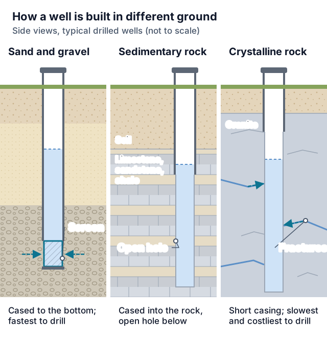
Much of the groundwater here comes from the Columbia River Basalt Group. A 1988 U.S. Geological Survey report on the Umatilla Plateau, prepared with OWRD (Water-Resources Investigations Report 87-4268), describes basalt flows ranging from a few feet to as much as 300 feet thick, separated by porous interflow zones of weathered basalt, flow-top breccia and scoria, sometimes with clay, silt and sand interbeds. It notes sediments of glaciofluvial origin and alluvium over the basalt near and along the Columbia River, and loess over much of the central part of its study area.
Umatilla County Service Details
What providers in this area actually see: coverage, common jobs, local pricing factors, and rules worth knowing.
Service Area Notes
- Places: the Census Bureau's 2020 Oregon place-to-county file puts the cities of Adams, Athena, Echo, Helix, Hermiston, Milton-Freewater, Pendleton, Pilot Rock, Stanfield, Ukiah, Umatilla and Weston in Umatilla County, along with the census-designated places of Cayuse, Gopher Flats, Green Meadows, Kirkpatrick, McKay, Meacham, Mission, Riverside, Tutuilla and Umapine. Every one of them still appears on the bureau's current TIGERweb layer.
- Nitrate area by ZIP code: Umatilla County Public Health describes the county's part of the Lower Umatilla Basin Groundwater Management Area (LUBGWMA) as Hermiston 97838, Stanfield 97875, Echo 97826 and Umatilla 97882. Residents there can apply for a free Oregon Health Authority (OHA) well test voucher, one per well, and the county's Environmental Health staff can help schedule the test and inspection.
- Records for nearby wells: OHA points well owners to OWRD's Well Report Query tool for a well's tag ID, well ID number, depth, and township, range and section. Under ORS 537.765 each log must show, among other items, the depth, diameter and type of the well, the kind and amount of casing and where it sits, the static water level, and the material in each stratum penetrated, with an entry for each change of formation.
Common Jobs in Umatilla County
- New domestic wells under the ORS 537.545 exemption, with the tax-lot map and $300 recording fee filed alongside the well report
- Deepening a basalt well; OAR 690-215-0045 allows it without an approved special standard only for a well whose original well report is referenced on or attached to the deepening report, or one recased and resealed to current minimum standards. The static water level must be measured and logged before and after. If the deeper hole reaches a new aquifer, every previous aquifer, including one that has gone dry or is low-producing, must be cased and sealed off by the division 210 methods before the deepening work is completed, and no deepening may commingle aquifers
- Replacement wells, where OAR 690-220-0035 requires an old well that lies within a setback to be permanently abandoned within one year after the new well takes over its function, or within one year after any water right is transferred to the new well, whichever is later
- Permanent abandonment of unused or dry wells to the division 220 standards
- Pump replacement, after which OWRD's disinfection rule says the well should also be disinfected
- Arsenic, nitrate and coliform sampling for a home sale or for routine checks
What Drives Pricing Here
- Start card fee: ORS 537.762(12) sets $490 for each start card covering a new well, the deepening of an existing well or a well conversion. OWRD's fee schedule, headed Effective July 1, 2025, lists the same $490 and applies it to water supply and monitoring wells. The enrolled HB 2808 (2025) raised the fee from $350; OWRD's HB 2808 page says the program's fee increases took effect July 17, 2025, and the act states the Legislative Assembly's intent that it apply retroactively to July 1, 2025.
- Recording fee: a new well built for an exempt use carries a one-time $300 recording fee under ORS 537.545(7). OWRD's recording fee page says the well constructor submits it with a map of the well's location on the property, or the landowner does when the well was built under a landowner permit and bond, and that the map and fee are due at the time the well report is submitted.
- Pump and depth: the 1988 USGS report says multiple center-pivot systems and greater depth to water in the uplands contributed to the drilling of deeper wells there, with higher-capacity pumps than those used in the valley bottoms. That passage is about irrigation wells, not house wells.
- Calculator limits: the drilling cost calculator on this site works from national averages. It takes the footage you enter, prices it at a per-foot band tied to your choice of sand, sedimentary rock, granite or unknown ground, and adds fixed ranges for a permit, a pump and a pressure tank. It offers no basalt option, its permit range is not Oregon's $490 start card, and none of the reports listed below states a typical depth for a Umatilla County well, so its output is a starting budget only.
Permits & Local Rules
- Who may build a well (ORS 537.747): advertising well construction, alteration, abandonment or conversion services, contracting for that work, causing it to be done under such a contract, or operating well drilling machinery all require an OWRD water well constructor's license in good standing, except that ORS 537.747(2) lets someone supervised by a licensee operate a drilling machine without one. OAR 690-205-0020(6) sets how close that supervision must be: a worker who holds no license, permit or trainee card may construct, alter, convert or abandon a water supply well only with a licensed constructor physically present at the well site at all times during that work, and the supervising constructor answers for compliance with every applicable statute and rule. Trainee cardholders follow separate conditions in section (4) of the same rule, which spell out when a trainee may run a machine without the licensee on site; ask OWRD before relying on them. The qualifications are set out in ORS 537.747(3) and OAR 690-205-0020. Anyone who contracts or offers to contract for this work must also keep a $20,000 surety bond or irrevocable letter of credit filed with the Water Resources Commission (ORS 537.753(1)).
- Building a well on your own land (ORS 537.753(4), OAR 690-205-0175): a property owner without a license may construct, alter, abandon or convert a well on property the owner owns only after obtaining an OWRD landowner permit, which takes a $550 fee and a $10,000 bond or irrevocable letter of credit, before work begins. Only the owner of record, a member of the owner's immediate family, or a full-time employee of the owner whose main duties are not well construction may run the drilling machine under that permit. The permit expires six months after issuance, and the landowner files a well report, certified by the landowner's signature, within 30 days of the permit expiring or of the well's completion, whichever comes first. Before sealing the well the landowner gives OWRD 10 days' written notice so staff can be present; once that period ends, the well may be sealed even if no one has inspected it. OWRD may deny the permit if the proposed work is a health threat, a health hazard, a source of contamination or a source of waste of groundwater, and the permit holder also files the start card.
- Start card timing (ORS 537.762): a separate card for each well, with the contents listed in subsection (2), goes to OWRD not earlier than 60 days and not later than 72 hours before work begins, and electronically unless the department authorizes another means. That window does not apply to a second or additional well on the same or a contiguous tax lot for the same landowner, where a valid, unexpired start card has already been submitted, if the added well's card is filed no later than the day its work begins, or to water emergencies and casing height adjustments, if a card is submitted before work begins. The Commission may set other exceptions by rule, and the Director may waive any time frame for good cause in exigent circumstances.
- After the card is filed: on the day work starts, the constructor or permit holder notifies OWRD before beginning, and if the seal will not go in on the date the card proposed, notifies OWRD of the change at least four hours before placing it. Unless an extension was requested and received, a start card expires if the work has not begun on or before 60 days after it was submitted, and a new card and fee are needed; OAR 690-205-0205(10) allows a card to be extended once, for up to 30 calendar days, in exigent circumstances, for good cause shown and with prior department approval; the rule defines good cause as exigent circumstances beyond the requester's reasonable control. The rule lists how requests are submitted: in writing on a department-approved form before the card expires, and electronically by department-approved methods. The form must give the start card number, a description of the circumstances that warrant the extension, the date of the request, the driller's name and license number, and the owner's name and contact information. A card withdrawn before it expires can have its fee moved to a new card on request.
- Well report (ORS 537.765, OAR 690-205-0210): a report is required for every well constructed, altered, converted or abandoned, unsuccessful and exempt-use wells included. On a constructor-built well, the constructor who built it signs it as correct, the bonded constructor responsible certifies it, and the bonded constructor files it with OWRD within 30 days after the work is completed (landowner permit holders follow the landowner rule above), electronically unless OWRD has given prior written approval for paper. For an exempt-use well, the tax-lot map and recording fee go in with the report no later than 30 days after completion (OAR 690-190-0100); that recording rule does not cover a well that is repaired, deepened or altered, or one permanently abandoned within 30 days of completion.
- Exempt uses (ORS 537.545(1)): no water right permit is needed for single or group domestic use of up to 15,000 gallons a day; stockwatering, unless the use exceeds 12,000 gallons a day at a new confined animal feeding operation as ORS 468B.215 defines it (the version operative September 15, 2027 drops that qualifier); watering a lawn or a noncommercial or commercial garden of up to one-half acre with up to 3,000 gallons a day; watering the lawns, grounds and fields, up to 10 acres, of schools located within a critical ground water area; down-hole heat exchange; any single industrial or commercial purpose, other than lawn or commercial garden watering, using no more than 5,000 gallons a day; and land application of reused groundwater on the conditions in (1)(g). Commercial garden watering combined with an industrial or commercial exempt use is capped at 5,000 gallons a day. A 2025 session law (Oregon Laws 2025, chapter 283, section 3) withdraws the commercial garden exemption inside the LUBGWMA; that section is repealed on January 2, 2028.
- Critical groundwater areas: OWRD's groundwater administrative areas table (rev. April 19, 2021) lists the Ordnance Basalt and Ordnance Gravel areas (April 2, 1976) and Butter Creek in Morrow and Umatilla counties, and Stage Gulch (May 15, 1991) in Umatilla County, each with exempt uses only as the allowable uses. OAR 690-507-0070 states that the Ordnance basalt and shallow gravel aquifers and the Butter Creek basalt aquifer are closed to further appropriation by order of the Director, and OAR 690-507-0770 bars OWRD from accepting new applications for water from the Stage Gulch basalt reservoir.
- Exempt wells inside Butter Creek and Stage Gulch: OAR 690-507-0635 and -0775 say water users exempt under ORS 537.545 (a), (b), (d), (e) and (f) are not subject to division 507, while a school watering up to ten acres from the basalt reservoir must meet the user requirements those rules cite. In Stage Gulch, wells located in Subarea E are also outside the division, except that a permitted well there may not be deepened to a point where it would penetrate the deep basalt reservoir under that subarea.
- Walla Walla subbasin (OAR 690-507-0030): its groundwater is classified for statutorily exempt uses only, and OWRD's table lists the area (May 11, 2017) in Umatilla County. The rule also sets up a Serious Water Management Problem Area with totalizing flow meter and annual water-use reporting duties for basalt wells inside it that are listed as a point of appropriation on a valid water right; owners of such wells should read section (4) of the rule for the meter specifications and deadlines.
- Setbacks (OAR 690-210-0030): no water supply well within 50 feet of a septic tank; 100 feet of a septic drainline or sewage disposal structure or facility; 50 feet of a closed sewage or storm drainage system, except those in or underneath a building; 50 feet of a confined animal feeding or holding area or of an animal waste holding area such as a pond or lagoon; 100 feet of a sewage sludge disposal area; 5 feet of a permanent structure or its roof, eaves or overhangs, decks and additions included, but not pump houses or other outbuildings that are easily moved; 500 feet of a hazardous waste storage, disposal or treatment facility without the Director's written permission; or 25 feet of a residential, or 50 feet of a commercial, petroleum storage tank, underground or aboveground. Rain gutter downspouts and drains are exempt. A well may be built at the site of an abandoned septic tank or drain field one year after it is taken out of use, once the tank has been pumped out by a DEQ licensed sewage disposal business and filled with reject sand, bar run gravel or other material the on-site permitting agent approves, and the delivery line from the building has been permanently capped or filled with cement grout. It may never pass through the old tank or drain line and must still meet the other setbacks. Wells serving public water systems also have OHA setback standards.
- Casing, sealing and testing: the casing head or pitless unit has to rise at least 12 inches above the finished ground surface or pumphouse floor and at least 12 inches above the local surface runoff level, unless the Director approves a reduction after an application describing the site and the extra protective steps (OAR 690-210-0250). For a well drilled into water-bearing rock beneath clay, silt, sand, gravel, cobbles or similar material, OAR 690-210-0150 offers three sealing methods, a continuous seal, step-down casing and under-reaming, each with its own drillhole, casing and grout requirements. Every completed well is tested for yield and drawdown by bailing, pumping or air testing for at least one hour (OAR 690-210-0370).
- Disinfection (OAR 690-210-0380): pumping equipment, sand, gravel and casing are hosed or sluiced with water and disinfected with a solution of at least 50 parts per million chlorine, and on completion the well is cleaned and dosed so that a 25 parts per million residual remains throughout after 24 hours. The rule adds that disinfection should also follow installation of pumping equipment.
- Abandonment (OAR 690-220-0030): a well being permanently abandoned, dry or non-producing wells included, is filled completely so that water cannot move vertically in the bore or in the annular space around the casing. Unless the rules say otherwise the work is done by a licensed water supply well constructor, and a landowner permit holder may do it on the landowner's own property. The procedure is recorded on an OWRD-approved form, and any well identification tag is destroyed rather than reused. Division 220 sets different fill materials and methods for cased, uncased, artesian, driven, filter pack and dug wells.
Geology & Water Table Notes
- Basalt aquifers: OWRD Groundwater Report No. 35 (Zwart, December 1990) says basalt of the Columbia River Basalt Group underlies all of the Stage Gulch area, represented there by the Grande Ronde, Wanapum and Saddle Mountain formations, with the Grande Ronde the thickest and most extensive. It explains that groundwater occurs and moves most readily in the interflow zones of weathered or vesicular flow tops and bottoms and sedimentary interbeds.
- Water levels at Stage Gulch (1990 report): citing an OWRD map for 1965 to 1980, Report 35 says many wells had declined 50 feet or more by 1980, with two localized areas of more than 100 feet. Winter measurements from 1980 to 1990 showed most further declines between 25 and 60 feet, with over 100 feet at some wells in the southwest part of the area, and no sign yet that levels were stabilizing.
- Wider plateau (1988 report): the abstract of USGS WRI 87-4268 says maximum water-level declines of about 300 feet occurred in parts of the Grande Ronde Basalt unit between 1950 and 1982, a period in which groundwater withdrawal rose to about 182 cubic feet per second.
- Nitrate: DEQ calls the LUBGWMA one of three groundwater management areas in Oregon. Its page cites a 2011 analysis by DEQ, the Oregon Department of Agriculture and OSU Extension that estimated about 70% of the nitrate came from irrigated farmland, about 13% from large dairy and cattle farms, about 8% from animal pastures, about 5% from food processors reusing wastewater on fields, and about 5% from residential septic systems and other sources.
- Free safe water services: OHA works with the Umatilla County Health Department, Morrow County Public Health, the Oregon Department of Human Services and community groups to provide free testing, water delivery or treatment to eligible households with private wells in the LUBGWMA, and what a household receives depends on its nitrate result. Businesses and facilities do not qualify, and OHA says free testing is not available to households outside the management area.
Communities Served
Hermiston · Pendleton · Umatilla · Stanfield · Echo · Milton-Freewater · Athena · Weston · Pilot Rock · Helix · Adams · Ukiah
Emergency Response Expectations
Lost water at a Umatilla County well? Flag your request as urgent. We pass it along to independent contractors and cannot promise a response time. ORS 537.762 lifts the 72-hour advance filing during water emergencies, but a start card must still be submitted before work begins.
Umatilla County FAQs
Do I need a water right for a house well in Umatilla County?
Not for single or group domestic use of up to 15,000 gallons a day, which ORS 537.545 exempts, and the Butter Creek and Stage Gulch rules do not apply to that use. The well still has to be built by a licensed constructor or under a landowner permit, with a start card before the work, a well report after it, and the $300 recording fee and tax-lot map for a new exempt-use well.
What water tests does Oregon require when a home with a well is sold?
Under ORS 448.271, once the seller accepts an offer, the seller has the well tested for arsenic, nitrates and total coliform bacteria, and must send the results to OHA and to the buyer within 90 days of receiving them. OHA's page adds that the samples must go to an accredited laboratory, that results are valid for one year, and that properties with spring wells, irrigation-only wells, or wells on undeveloped land are exempt. OHA may by rule add tests for specific contaminants in areas of public health concern.
How often does OHA suggest testing a private well?
OHA's routine testing table suggests coliform and E. coli bacteria and nitrate every year and arsenic every 3 to 5 years, and says you may need to test more often if the well has a history of contamination, a septic system recently malfunctioned, household members have a stomach illness, infants are drinking the water, or equipment has broken or malfunctioned. OHA says Oregon requires testing only when a property with a well is sold, with separate rules for new wells, and that routine results need not be reported.
What free nitrate help is there near Hermiston?
Inside the LUBGWMA, OHA bases the offer on the household's nitrate result. At 0 to 4.99 milligrams per liter it offers a free yearly lab test that the household self-samples any time from July through September. From 5 to 9.99, the county health department collects a sample quarterly until a year of testing in every season is complete; after that the household can keep testing free each quarter by self-sampling unless nitrate rises to 10 or more. From 10 to 24.99 the household qualifies for free drinking water delivery and is offered a free reverse osmosis system, whose treated water the licensed plumbers who install it test after installation and whenever filters are changed, and it can also self-sample its untreated well water for a free annual test from July through September. At 25 or more the household should be receiving free drinking water delivery that meets its needs and has the option of the same free July-to-September self-sampled test; OHA says a reverse osmosis system will not be effective enough above 25. Only eligible households with private wells inside the management area qualify; businesses and facilities do not. See OHA's LUBGWMA FAQ for the full terms.
Can I start drilling the day after the start card is filed?
Normally no. The card must be submitted at least 72 hours, and no more than 60 days, before work begins, and it expires if work has not begun within 60 days of submission unless an extension was granted. The listed exceptions are an additional well on the same or a contiguous tax lot for the same landowner with a valid card already on file, water emergencies, casing height adjustments, rules the Commission adopts, and a Director's waiver for good cause in exigent circumstances.
Sources
- Oregon Legislature: ORS chapter 537 (537.545, 537.747, 537.753, 537.762, 537.765)
- Oregon Legislature: ORS chapter 448 (448.271 Domestic Well Testing Act)
- Oregon Legislature: HB 2808 (2025), enrolled
- OWRD: Fee schedule, effective July 1, 2025
- OWRD: House Bill 2808 fee increases
- OWRD: Groundwater use recording fee
- OWRD: Groundwater administrative areas and critical groundwater areas
- OWRD: Table of groundwater administrative areas (rev. 2021-04-19)
- OWRD Groundwater Report No. 35: Stage Gulch area (1990)
- Oregon Secretary of State: OAR 690-507, Umatilla Basin Program
- Oregon Secretary of State: OAR 690-190, exempt use recording
- Oregon Secretary of State: OAR 690-205, licensing, start cards, well reports
- Oregon Secretary of State: OAR 690-210, well construction standards
- Oregon Secretary of State: OAR 690-215, maintenance, repair and deepening
- Oregon Secretary of State: OAR 690-220, abandonment of water supply wells
- Oregon DEQ: Nitrate contamination, Lower Umatilla Basin
- OHA: Domestic well testing at real estate transactions
- OHA: Routine domestic well testing
- OHA: Nitrate testing, treatment and water delivery, Lower Umatilla Basin
- OHA: LUBGWMA frequently asked questions
- Umatilla County Public Health: Domestic well testing
- USGS WRI 87-4268: Umatilla Plateau and Horse Heaven Hills geohydrology (1988)
- Census Bureau: 2020 Oregon place-by-county codes
- Census TIGERweb: current incorporated places, Umatilla County cities
Last reviewed 2026-10-30
Services Available in Umatilla County
Well Drilling
New residential wells — find local drillers for site evaluation, depth estimates, and written drilling quotes.
Learn more →Water Well Drilling
Household water wells from site evaluation through casing, pump, and water test — written quotes from local drillers.
Learn more →Well Pump Repair
No water at the tap? Request urgent well pump repair — local pros diagnose pressure loss, dead pumps, and pressure tank failures fast.
Learn more →Well Pump Replacement
Pump at end of life or beyond repair? Get quotes for correctly-sized submersible and jet pump replacement from local well pros.
Learn more →Well Inspection & Testing
Buying a home with a well, or overdue for a water test? Local pros for flow tests, equipment inspection, and lab water-quality testing.
Learn more →Well Water Service
Water quality problems, treatment systems, and general well maintenance — connect with local pros for everything between drilling and pump work.
Learn more →Free Tools Before You Call
Ballpark the cost or narrow down the problem before talking to an Umatilla County provider.
Well Drilling Cost Calculator
Estimate what drilling a well should cost — by depth, geology, and whether you need the pump and pressure tank included.
Use the free tool →No Water From Your Well? Diagnostic Wizard
Suddenly no water in the house? Answer a few questions to find out if it's the breaker, the pressure switch, the tank, the pump — or the well itself.
Use the free tool →Well Pump Size Calculator
Find what size well pump you need — GPM demand, total dynamic head, and a horsepower recommendation from four quick inputs.
Use the free tool →Need help in Umatilla County, OR?
Send the short form — urgent requests get priority routing.