Well Drilling in McLennan County, TX
Well drilling typically runs $3,000–$16,000 nationally, per our cost guide. Independent local pros serving Waco, Bellmead, Beverly Hills and nearby communities. Describe the problem and we'll route your request — free, no obligation.
- Mark no-water pump problems as emergencies on the form
- County pages on local well depths, aquifers, and permits
- Well inspections, water testing, and treatment
- Free to use — no obligation, no markup
Fast response from independent local providers. No obligation.
Typical national cost$3,000 – $16,000Cost guide →Local Help in McLennan County, TX
Water wells in McLennan County fall under the Southern Trinity Groundwater Conservation District, whose enabling act (Special District Local Laws Code chapter 8821) made its initial boundaries coextensive with the county's. Rule 5.601(a) of the district rules, amended and effective November 16, 2023, says no person may drill or operate an exempt well in the district without first registering it on a district-approved form and obtaining written district approval of the registration and agreement that the well qualifies as exempt.
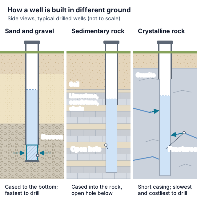
The district's management plan, approved by its board on July 15, 2021, describes the Trinity Aquifer as confined throughout the county, recharged outside the district to the north and west, and dipping southeast so that it lies deeper in the district's eastern part, with the Balcones Fault Zone accentuating that deepening. Near the river, the plan describes the Brazos River Alluvium as a separate, unconfined aquifer, and the rules give it its own exemption limits.
McLennan County Service Details
What providers in this area actually see: coverage, common jobs, local pricing factors, and rules worth knowing.
Service Area Notes
- Places listed below come from rows coded to McLennan County (county code 309) in the Census Bureau's 2020 Texas place-by-county listing: incorporated cities, except Crawford (a town) and China Spring and Willow Grove (census designated places), and every one still appears on TIGERweb's current place layers. In that file Valley Mills also has a Bosque County row, McGregor a Coryell County row, Bruceville-Eddy and Golinda Falls County rows, and Mart a Limestone County row.
- Rule 5.601(c)(6) lists, among the findings for approving a registration, that the wellhead is or will be physically located within the district's boundaries, so confirm the county of the well site itself.
- District rules split the Trinity into a Hensell Management Zone, generally in the county's northwestern portion, and a Hosston Management Zone, generally in its central and southeastern portion. The plan says permitted wells in each zone predominately draw from that zone's stratum, the upper Hensell or lower Hosston, while some wells may draw from both.
Common Jobs in McLennan County
- Exempt household and livestock wells, drilled after the district approves the registration
- Hensell or Hosston wells sited to meet Rule 6.103 spacing, or under a board-granted variance
- Brazos River Alluvium wells within the Rule 5.501(a)(4) tract limits
- Electric or geophysical logs for new Trinity wells (Rule 6.227)
- Replacement wells under Rule 6.223
- Pump installation and repair, licensed separately from drilling
- Plugging deteriorated or abandoned wells and filing the plugging report
What Drives Pricing Here
- Target stratum: the plan names the Paluxy, Hensell and Hosston as the Trinity's water-bearing strata in the district, with the Paluxy only in the western part and very little or no use of it in the county, and says that as the aquifer dips southeast the Hensell and Hosston become divided by several formations, including the Pearsall, Cow Creek, Hammett and Sligo. Ask each driller which stratum and depth the quote assumes.
- Registration fee: the district's exempt-well registration forms, marked revised 11/2025, require a $1,000.00 fee with the form for a well over 100 feet and $100.00 for one under 100 feet, by personal or cashier's check or money order (no cash), on a completed, signed and notarized form. Rule 7.1(b) lets the district refuse a registration filed without its fee.
- Logging: within 60 days after drilling any well completed to be capable of producing Trinity water, Rule 6.227 has the well owner and/or operator deliver to the district an electric or geophysical log showing at least electrical conductance, spontaneous potential and natural gamma. Check that the quote covers it.
Permits & Local Rules
- Exemption: under Rule 5.501(a)(2) and (b)(2), a well needs neither a district withdrawal permit nor a drilling permit when it sits on more than 10 acres, has a capacity, as drilled, completed or equipped, of no more than 25,000 gallons a day, and is used solely for domestic use or livestock or poultry, the exemption Water Code 36.117(b)(1) requires. The district may still require a permit when a Water Code 36.117(d) criterion is met (Rule 5.501(d)), and a well later altered, equipped or used in a non-exempt way loses the exemption (Rule 5.501(k)).
- Smaller tracts: Rules 5.501(a)(4) and 5.501(c) exempt a well only from the withdrawal permit; the drilling-permit exemptions in Rule 5.501(b) do not list them, so ask the district what else applies. For a domestic, livestock or poultry well completed and capable of withdrawing water solely from the Brazos River Alluvium, the incapable-of-producing caps are 2,500 gallons a day under 2 acres, 5,000 at 2 to under 5 acres, 12,000 at 5 to under 7, and 17,000 at 7 to under 10. A well completed and capable of withdrawing solely from the Trinity, for those uses, qualifies only if no public water supply is available to the tract, with caps of 1,000 gallons a day under 2 acres, 2,000 at more than 2 but under 5, 4,000 at 5 to under 7, and 6,000 at 7 to under 10.
- Location, Rule 6.101: every new well must be at least 50 feet from any property line; no new well may be within 500 feet of a sewage treatment plant, solid waste disposal site or land irrigated by sewage plant effluent, or within 300 feet of a sewage wet well, sewage pumping station, or drainage ditch that contains industrial waste discharges or wastes from sewage treatment systems. New wells other than dewatering and monitoring wells must also meet TDLR's location rules in 16 TAC chapter 76.
- Spacing, Rule 6.103: a new Hensell or Hosston well with a maximum production capacity of 50 gallons per minute or less must be at least 1,000 feet from any other well, other than an abandoned well, completed in the same management zone; above 50 gallons per minute, add 20 feet per gallon per minute over 50, measured from any other well completed in that zone. Replacement, dewatering and monitoring wells are excluded, as are wells completed on or before February 28, 2008, unless later modified to substantially increase capacity. Rule 5.501(h) applies spacing to exempt wells too, except Brazos River Alluvium wells exempt under Rule 5.501(a)(4).
- Spacing variance: only the board can grant a variance from Rule 6.103, under the eligibility conditions in Rule 6.107, and owners of wells within the spacing distance may protest; Rule 6.105 lists what the application must contain. Talk to the district before relying on one.
- Non-exempt wells: Rule 6.201(b) requires a district well drilling permit before drilling, equipping or completing a non-exempt well, physically altering an exempt well into a non-exempt one, or increasing the size or capacity of a well or well pump; maintenance or repair that does not raise production capability above the authorized rate is excepted unless it converts an exempt well (Rule 6.201(d)).
- Notice and posting: for work authorized by a well drilling permit, the permittee (Rule 6.221) and the driller (Rule 6.303) must each give the district at least 3 days' notice of the intent to commence, so a district representative may attend and observe at the district's discretion. Before drilling any well, the driller must confirm with the district that each required permit or registration is issued and in effect, and keep a copy posted where visitors can easily see it during drilling or construction (Rule 6.305).
- Licensing: Sec. 1901.151 of the Occupations Code bars anyone without a chapter 1901 license from acting as a driller or offering to, and Sec. 1902.151 requires a chapter 1902 license for pump installers; TDLR administers both. Both chapters' definitions exclude a person working, for personal use, on property that person owns, plus an assistant who works under a licensee's direct supervision without primary responsibility for the job. 16 TAC 76.30, Secs. 1901.161 and 1902.161 and district Rule 6.301(d) add other exemptions, each with its own limits. Under Rule 6.301(e), licensed or not, the work must meet 16 TAC chapter 76 and the district rules, the more stringent governing in a conflict.
- Well records: Rule 6.307 has the driller of any well in the district, exempt or not, keep an accurate driller's log at least three years and, within 60 days after the well is completed, file with the district the log, a report detailing the drilling, equipping and completing of the well, any electric or geophysical log, pump test results, water quality sampling results and well video surveys if performed, and copies of everything about the well submitted to any Texas agency. Under 16 TAC 76.70(1), by the 60th day after the well's drilling, deepening or other alteration is finished or stops, its driller owes TDLR a State of Texas Well Report, sent electronically using the state-run Texas Well Report Submission and Retrieval System, plus copies for the district and for the owner or whoever contracted for the drilling.
- Replacements: Rule 6.223 sets location, size and filing conditions for a replacement well, and the old well must stop producing and within 90 days be plugged, capped, or re-equipped and registered as an exempt well or re-equipped as a monitoring well. Read the rule with the district before drilling.
- Old wells: Rule 6.501 makes the well owner and/or operator responsible for plugging, or having plugged, any deteriorated or abandoned well under Occupations Code chapter 1901 and 16 TAC chapter 76. Under the district's definitions, six consecutive months without use makes a well abandoned, though a well that is not deteriorated still counts as in use while its casing, pump and pump column remain in good condition, or once it has been properly capped. Statewide, Occupations Code 1901.255(c) sets a deadline of the 180th day after the landowner or other possessor learns of an abandoned or deteriorated well's condition, by which the well has to be plugged or capped following state standards; ask the district which duty applies. Under 16 TAC 76.104(a), plugging may be done by a licensee or by the well owner, following that rule's specifications and the district's rules. The person who plugs a well owes the plugging report within 30 days after plugging is complete: to the district under Rule 6.503, and under 16 TAC 76.70(3) to TDLR, the district and the owner or person the well was plugged for.
- Questions about a specific site go to the district through the contact page on its website.
Geology & Water Table Notes
- Rule 1.1(73) defines the Trinity Aquifer as the Paluxy, Glenn Rose, Hensell, Pearsall, Cow Creek, Hammett, Sligo and Hosston formations. The plan says the formations other than the Hensell and Hosston are not major contributors to production.
- District groundwater level monitoring, per the plan, has shown a faster annual decline in Hensell zone wells than in Hosston zone wells. On its Trinity page TWDB says some of the biggest groundwater-level drops in Texas, between 350 and over 1,000 feet, happened in counties along the IH-35 corridor from McLennan County to Grayson County; it attributes them primarily to municipal pumping and says they have slowed over the past decade with increasing reliance on surface water.
- TWDB's statewide summaries: in the Trinity outcrop the water is fresh yet very hard, and dissolved solids, below 1,000 mg/L toward the east and southeast, reach 1,000 to 5,000 mg/L as the aquifer lies deeper. Brazos River Alluvium water is very hard and fresh to slightly saline, generally under 1,000 milligrams per liter but up to 3,000 in some wells.
Communities Served
Waco · Bellmead · Beverly Hills · Bruceville-Eddy · China Spring · Crawford · Gholson · Golinda · Hallsburg · Hewitt · Lacy-Lakeview · Leroy · Lorena · Mart · McGregor · Moody · Riesel · Robinson · Ross · Valley Mills · West · Willow Grove · Woodway
Emergency Response Expectations
Repairing an existing pump is pump installation under Occupations Code 1902.001(8), which takes a TDLR pump installer license unless an exclusion or exemption applies. If you believe a well condition may pollute or degrade the groundwater, Rule 6.219 requires written notice to the district within 48 hours of learning of it.
McLennan County FAQs
What does the Southern Trinity GCD charge to register an exempt well?
The registration forms marked revised 11/2025 list $1,000.00 for a well over 100 feet and $100.00 for one under 100 feet. The spacing variance application form leaves its fee blank, so ask the district.
Can I drill a Trinity well on a small lot?
Possibly. The Rule 5.501(c) small-tract limits apply only where no public water supply is available to the tract, the well must stand 50 feet from property lines, and a Hensell or Hosston well must meet Rule 6.103 spacing or obtain a board variance from it.
How can I find depths of nearby wells?
For wells drilled after 2002, TDLR's water well page points to the Texas Well Reporting System; the district also receives drillers' logs under Rule 6.307.
What water test does TCEQ describe for a private well?
GI-433, a TCEQ guide revised in June 2023, walks through total coliform and E. coli sampling: the sterile container and form come from an accredited drinking water lab, and testing has to happen within 30 hours of collecting the sample. Its scope is microbial contaminants only.
Sources
- Southern Trinity GCD Rules, Nov. 16, 2023
- Southern Trinity GCD Management Plan, July 15, 2021
- Exempt well registration over 100 ft (rev. 11/2025)
- Exempt well registration under 100 ft (rev. 11/2025)
- Spacing variance application
- Southern Trinity GCD: Contact
- Special District Local Laws Code ch. 8821
- Water Code ch. 36
- Occupations Code ch. 1901
- Occupations Code ch. 1902
- 16 TAC 76.30
- 16 TAC 76.70
- 16 TAC 76.104
- TDLR: Water well drillers and pump installers
- TDLR: Abandoned wells
- TWDB: Trinity Aquifer
- TWDB: Brazos River Alluvium Aquifer
- TCEQ GI-433 (June 2023)
- Census: 2020 Texas places by county
- Census: TIGERweb places
Last reviewed 2026-11-01
Nearby Counties
Services Available in McLennan County
Well Drilling
New residential wells — find local drillers for site evaluation, depth estimates, and written drilling quotes.
Learn more →Water Well Drilling
Household water wells from site evaluation through casing, pump, and water test — written quotes from local drillers.
Learn more →Well Pump Repair
No water at the tap? Request urgent well pump repair — local pros diagnose pressure loss, dead pumps, and pressure tank failures fast.
Learn more →Well Pump Replacement
Pump at end of life or beyond repair? Get quotes for correctly-sized submersible and jet pump replacement from local well pros.
Learn more →Well Inspection & Testing
Buying a home with a well, or overdue for a water test? Local pros for flow tests, equipment inspection, and lab water-quality testing.
Learn more →Well Water Service
Water quality problems, treatment systems, and general well maintenance — connect with local pros for everything between drilling and pump work.
Learn more →Free Tools Before You Call
Ballpark the cost or narrow down the problem before talking to a McLennan County provider.
Well Drilling Cost Calculator
Estimate what drilling a well should cost — by depth, geology, and whether you need the pump and pressure tank included.
Use the free tool →No Water From Your Well? Diagnostic Wizard
Suddenly no water in the house? Answer a few questions to find out if it's the breaker, the pressure switch, the tank, the pump — or the well itself.
Use the free tool →Well Pump Size Calculator
Find what size well pump you need — GPM demand, total dynamic head, and a horsepower recommendation from four quick inputs.
Use the free tool →Need help in McLennan County, TX?
Send the short form — urgent requests get priority routing.