Well Drilling in Grayson County, TX
Well drilling typically runs $3,000–$16,000 nationally, per our cost guide. Independent local pros serving Sherman, Denison, Van Alstyne and nearby communities. Describe the problem and we'll route your request — free, no obligation.
- Mark no-water pump problems as emergencies on the form
- County pages on local well depths, aquifers, and permits
- Well inspections, water testing, and treatment
- Free to use — no obligation, no markup
Fast response from independent local providers. No obligation.
Typical national cost$3,000 – $16,000Cost guide →Local Help in Grayson County, TX
Grayson County shares the Red River Groundwater Conservation District with Fannin County; chapter 8859 of the Special District Local Laws Code, the 2009 act creating it, made its initial boundaries coextensive with the two counties. District Rule 3.1(a) requires every water well to be registered unless Rule 3.1(b) excuses it, a Notice to Proceed before a new exempt well is drilled, and a Production Permit ahead of drilling any new non-exempt well.
Rule numbers below come from the rules PDF on the district's site (cover: "As Amended on October 20, 2022"). Signed minutes record rule amendments adopted October 19, 2023 to meet a legislative petition-for-rulemaking requirement, and a well spacing evaluation update and new Board rule committee on July 16, 2026; check for a newer rules file before relying on a rule number.
Grayson County Service Details
What providers in this area actually see: coverage, common jobs, local pricing factors, and rules worth knowing.
Service Area Notes
- Places with Grayson County territory in the Census Bureau's 2020 place-to-county list: the cities of Denison, Dorchester, Gunter, Knollwood, Pilot Point (shared with Cooke and Denton counties), Sadler, Sherman, Southmayd, Tom Bean, Trenton (shared with Collin and Fannin), Van Alstyne (shared with Collin) and Whitesboro; the towns of Bells, Collinsville, Howe, Pottsboro, Tioga and Whitewright (shared with Fannin); and the census-designated places of Preston and Sherwood Shores. The Bureau's current TIGERweb place layers list each with the same status.
- Other approvals: signers of the district's new-well application (form RRGCD-100, rev. 06/2022) acknowledge that the county, a municipality or another political subdivision may impose additional drilling and completion requirements under certain conditions, and that obtaining any such approval is the signer's responsibility.
Common Jobs in Grayson County
- New household wells equipped for 17.36 gpm or less, the ceiling under Rule 3.7(a)(3) for registered wells drilled since January 1, 2019 to stay outside district permitting
- Replacement wells, which need district authorization before drilling (Rule 4.5)
- Plugging abandoned or deteriorated wells and filing plugging reports
- Total coliform and E. coli sampling through an accredited lab
What Drives Pricing Here
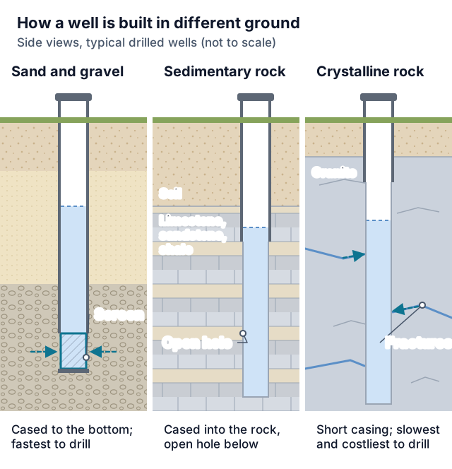
- Target depth: the district's 2022-2027 management plan, adopted June 23, 2022, puts the top of the Trinity Group's Antlers and Paluxy formations at approximately 500 feet in northwest Grayson County, deepening to over 3,500 feet in southeast Fannin County, and says only the lower two of the Woodbine's three water-bearing zones are developed for domestic and municipal supply.
- Capacity tier: a new well equipped for more than 17.36 gpm falls outside the Rule 3.7(a)(3) exemption and needs a Production Permit before drilling (Rule 3.9) unless another Rule 3.7(a) exclusion covers it, such as wells for certain limited oil and gas operations exempted under Water Code 36.117(b), which must still meter, report and pay production fees (Rule 3.7(b)); ask the district how a planned well is classified. Above 17.36 gpm the larger Rule 4.2(b) spacing distance applies, and Rule 10.1 requires a meter on a well not exempt under Rule 3.7(a), with exceptions and alternatives the rules set, among them a bolted blind flange the district seals in the interim when a new well's installed pump cannot yet run, until a flow test, and another reliable meter type or alternative measuring method if the district grants an application for it; ask the district what a planned well needs. The district's FAQ says non-exempt wells other than agricultural wells pay a production fee, and the fee schedule effective August 1, 2025 lists the agricultural-use water use fee as $0.
- District fees: the schedule on the district's Fees page, effective August 1, 2025 by the Board's July 24, 2025 vote, lists $100 to register a well under 17.36 GPM, $750 for a new well registration and Production Permit application above 17.36 GPM (also applied to permit amendments), $2,500 more when a Hydrogeological Report is required (200 GPM or more), and a $250 well driller log deposit, refundable if the conditions in the district rules are met. The September 17, 2026 Board packet carried a draft 2027 schedule with a $250 registration fee; minutes showing what was adopted, and when it takes effect, were not posted at this review, so confirm amounts with the district.
- Wellhead fittings: Rule 4.4(f) requires wells drilled on or after January 1, 2017 to have an above-ground, readily accessible backflow prevention device or an air gap at the well discharge, and Rule 4.4(g) requires at least one of the discharge set-ups it lists so the district can meter the flow.
Permits & Local Rules
- Registration (Rules 3.2-3.3): before a new well other than a leachate or monitoring well is drilled, equipped or completed, or an existing well is substantially altered, the owner, driller or another legally authorized person needs an approved registration, payment of the Rule 9.11 fees and the well report deposit. The form's required contents are set out in Rule 3.2(b), and Rule 3.3(b) covers the 30-business-day completeness review, the 120-day expiry of incomplete applications and the conditions for approval without a hearing; the General Manager's ruling can be taken to the Board through a written hearing request.
- Drilling window (Rule 3.3(d)-(e)): the registrant must drill and complete the well within 240 days after approval, or the registration expires. The registrant may apply for one extension of an additional 240 days or may resubmit an identical registration without another administrative fee, and an expired registration can be resubmitted only after 30 calendar days. Wells that state law requires TCEQ to approve before operation get 365 days, with up to two 365-day extension options, granted only on proof that the district determines warrants an extension. Rule 3.3(h) keeps every new well within 30 feet of the location in its Notice to Proceed.
- District spacing (Rule 4.2(b)): 50 feet from the property line for every new well; from existing registered wells in the same aquifer, 100 feet for a well equipped for 17.36 gpm (25,000 gallons per day) or less, and 889 feet plus 2.5 times the gpm for a larger one. Unregistered wells are not considered in that review (Rule 3.1(b)). Rule 4.3 sets an exception route with its own application, notice, hearing and waiver provisions; ask the district before counting on one.
- State construction rules: 16 TAC §76.100 sets siting distances from septic systems, livestock and poultry yards and other contamination sources, with listed exceptions and an alternative for cemented or pressure-filled wells, along with annular-seal and surface-completion standards. District Rule 4.4(e) requires a well penetrating more than one aquifer or aquifer subdivision to be completed so the waters do not commingle where 16 TAC chapter 76 requires it, with the method shown on the well report.
- Reports and deposit: within 60 days after drilling, deepening, completing or altering a well, the person who did the work files the well report with driller's log and the district's well completion report with the district (Rule 3.4(b)), and new and altered wells must undergo a district flow test within that deadline (Rule 11.4). TDLR's own clock under 16 TAC §76.70(1) runs from the completion or cessation of the drilling, deepening or alteration: by the 60th day the driller sends the log copy to TDLR electronically through its Texas Well Report Submission and Retrieval System, with copies due to the district and to the owner (or the person for whom it was drilled) as well. The deposit comes back when reports are timely and the flow test is done; it is forfeited if those deadlines are missed or the registration's rights are not timely used, and it is not returned if the district cannot flow test the well (Rules 3.3(g), 9.10).
- Licensing: TDLR licenses both trades; under Occupations Code 1901.151 and 1902.151 nobody may work as, or offer services as, a driller or pump installer while unlicensed. The statutory definitions carve out owners working on their own land for their own use (drilling a water well, or installing or repairing well pumps and equipment) and helpers working under a driller's or installer's direct supervision who carry no primary responsibility for the drilling operation or installation; 16 TAC §76.30(3) also lets a person install or repair pumps for their own use on land they lease or rent. Sections 1901.161 and 1902.161 and the rest of §76.30 add narrower exemptions worth reading before relying on one.
- Plugging: Occupations Code 1901.255(c) requires the landowner or other person possessing an abandoned or deteriorated well (terms that section defines) to have it plugged or capped, under standards and procedures adopted by the Texas Commission of Licensing and Regulation, within 180 days after learning of its condition; 16 TAC §76.104 sets the methods and material limits. District Rule 3.4(d) requires an inactive well whose pump equipment was removed with the intention of re-equipping it later to be capped, unless deteriorated casing could let water strata commingle and degrade water quality, in which case the well must be plugged or repaired. The installed cap needs to bear 400 pounds or more and be made so a person cannot easily pull it off by hand. Capping lasts until whatever condition required it is eliminated or repaired, and whichever of the well owner, driller or licensed pump installer did the capping files the district's well capping notice form with the district. Plugging reports go to the district within 30 days (Rule 3.4(c)) and, under §76.70(3), to TDLR within 30 days, with a copy to the owner.
- Testing: TCEQ's GI-433 (revised June 2023) explains sampling for total coliform and E. coli through an accredited lab, with the sample tested within 30 hours of collection. If total coliform is present it says to stop using the water for drinking, bathing, cooking, preparing food, making ice, washing dishes or cleaning, use boiled, disinfected, bottled or other water, disinfect the well and retest until a lab reports total coliform absent.
Geology & Water Table Notes
- Aquifer names: the district's management plan lists the Trinity units in the district as the Antlers (which includes all of the Trinity Group formations), the Paluxy Sand, the Glen Rose Limestone and the Twin Mountain. TWDB says the Woodbine Aquifer overlies the Trinity and forms three distinct water-bearing zones in sandstone interbedded with shale and clay.
- Woodbine quality: the plan says chemical quality deteriorates rapidly below 1,500 feet and is considered good overall between the outcrop and that depth as long as upper-Woodbine water is sealed off.
- Trinity: TWDB says the water is fresh but very hard in the outcrop, that total dissolved solids, sulfate and chloride generally climb as the aquifer deepens, and that some of the state's largest water-level declines, 350 to more than 1,000 feet, occurred in counties along IH-35 from McLennan County to Grayson County.
- Red River alluvium: the plan says state well reports from northern Fannin County and the northeast corner of Grayson County show water-bearing alluvium along the river up to about 95 feet deep and averaging 50 feet thick, and gives well yields in it of 1 to 150 gallons per minute, averaging about 25.
Communities Served
Sherman · Denison · Van Alstyne · Whitesboro · Pottsboro · Howe · Gunter · Tioga · Collinsville · Whitewright · Tom Bean · Bells · Southmayd · Knollwood · Dorchester · Sadler · Pilot Point · Trenton · Preston · Sherwood Shores
Emergency Response Expectations
Choose the emergency option on the request form when a well quits. Rule 3.6 needs no registration amendment for maintenance or repair that does not increase the pump's designed production capabilities.
Grayson County FAQs
Is a household well in Grayson County exempt from a district permit?
A well registered and drilled on or after January 1, 2019 that can produce 17.36 gallons per minute or less as equipped is outside the permitting requirements (Rule 3.7(a)(3)); the district's FAQ says this applies regardless of use or tract size and that exempt wells are not subject to permitting, metering, production reporting or production fees. It still needs registration, a Notice to Proceed and compliance with spacing. Texas Water Code 36.117(b)(1) sets the minimum exemption every district must give: a well whose water goes only to domestic use or to livestock or poultry, on a tract of more than 10 acres, and drilled, completed or equipped so it cannot produce over 25,000 gallons per day; under 36.117(j) that exemption does not reach a well whose water serves a subdivision whose plat needs approval under Local Government Code chapter 232. A well later substantially altered so it loses exempt status needs a Production Permit (Rule 3.9).
Can I drill a replacement for a failing well?
Only with district authorization first (Rule 4.5), and only for a well registered as of January 1, 2019. The General Manager may grant it without notice or hearing, subject to appeal to the Board. The replacement must be within 50 feet of the old well, in the same aquifer, farther than the old well from the nearest existing registered well where the property configuration makes that possible, and no larger in designed capacity than the well and pump replaced. Once the replacement begins producing, all production from the old well must cease, and the old well must be plugged no later than 90 days after the replacement's completion. Added capacity brings Rule 4.2 spacing for the increase, a Production Permit or amendment if Rules 3.9 or 3.15 require one, and loss of any Rule 3.7(a) exemption.
Is iron a problem in Woodbine wells?
TWDB says the Woodbine's upper zone yields limited water that tends to be very high in iron, and the district's plan reports excessive iron along the outcrop and extremely poor quality water downdip in the upper Woodbine. A lab test shows what a given well's water holds.
Sources
- Red River GCD: Rules (as amended October 20, 2022)
- Red River GCD: Registration and permitting
- Red River GCD: FAQs
- Red River GCD: Fee schedule effective August 1, 2025
- Red River GCD: July 24, 2025 minutes
- Red River GCD: September 17, 2026 Board packet
- Red River GCD: October 19, 2023 minutes
- Red River GCD: July 16, 2026 minutes
- Red River GCD: 2022 Management Plan
- Red River GCD: New well registration form RRGCD-100
- Special District Local Laws Code ch. 8859
- Texas Water Code ch. 36
- Texas Occupations Code ch. 1901
- Texas Occupations Code ch. 1902
- 16 TAC §76.100 (Texas SOS)
- 16 TAC §76.104 (Texas SOS)
- 16 TAC §76.70 (Texas SOS)
- 16 TAC §76.30 (Texas SOS)
- TDLR: Water Well Drillers and Pump Installers
- TWDB: Woodbine Aquifer
- TWDB: Trinity Aquifer
- TCEQ GI-433 (rev. June 2023)
- Census Bureau: TIGERweb places layers (current)
- Census Bureau: 2020 places by county, Texas
Last reviewed 2026-10-30
Nearby Counties
Services Available in Grayson County
Well Drilling
New residential wells — find local drillers for site evaluation, depth estimates, and written drilling quotes.
Learn more →Water Well Drilling
Household water wells from site evaluation through casing, pump, and water test — written quotes from local drillers.
Learn more →Well Pump Repair
No water at the tap? Request urgent well pump repair — local pros diagnose pressure loss, dead pumps, and pressure tank failures fast.
Learn more →Well Pump Replacement
Pump at end of life or beyond repair? Get quotes for correctly-sized submersible and jet pump replacement from local well pros.
Learn more →Well Inspection & Testing
Buying a home with a well, or overdue for a water test? Local pros for flow tests, equipment inspection, and lab water-quality testing.
Learn more →Well Water Service
Water quality problems, treatment systems, and general well maintenance — connect with local pros for everything between drilling and pump work.
Learn more →Free Tools Before You Call
Ballpark the cost or narrow down the problem before talking to a Grayson County provider.
Well Drilling Cost Calculator
Estimate what drilling a well should cost — by depth, geology, and whether you need the pump and pressure tank included.
Use the free tool →No Water From Your Well? Diagnostic Wizard
Suddenly no water in the house? Answer a few questions to find out if it's the breaker, the pressure switch, the tank, the pump — or the well itself.
Use the free tool →Well Pump Size Calculator
Find what size well pump you need — GPM demand, total dynamic head, and a horsepower recommendation from four quick inputs.
Use the free tool →Need help in Grayson County, TX?
Send the short form — urgent requests get priority routing.