Well Drilling in Itasca County, MN
Well drilling typically runs $3,000–$16,000 nationally, per our cost guide. Independent local pros serving Grand Rapids, Cohasset, La Prairie and nearby communities. Describe the problem and we'll route your request — free, no obligation.
- Mark no-water pump problems as emergencies on the form
- County pages on local well depths, aquifers, and permits
- Well inspections, water testing, and treatment
- Free to use — no obligation, no markup
Fast response from independent local providers. No obligation.
Typical national cost$3,000 – $16,000Cost guide →Local Help in Itasca County, MN
Wells in Itasca County are regulated by the state. On MDH's list of delegated well programs (page dated March 12, 2025), ten boards of health, covering eight counties and two cities, handle well permitting and inspection locally; Itasca is not among them. Construction and sealing notifications, fees and well records here go to MDH's Well Management Section. Because that state notification preempts local well permits and notifications, neither the county nor a city in it may require its own well permit or notification unless MDH delegates that authority under § 103I.111 (Minnesota Statutes § 103I.205, subd. 1(c)).
Itasca County Environmental Services handles planning and zoning, zoning permits, the subsurface sewage treatment system (SSTS) program and shoreland alterations, and its septic page says permits to install, construct, extend or alter an SSTS must be obtained from that office. The state well code is what links the two: it fixes how close a water-supply well may be to a septic tank, to a soil dispersal system's absorption area, and to the ordinary high water level of a lake or stream.
Itasca County Service Details
What providers in this area actually see: coverage, common jobs, local pricing factors, and rules worth knowing.
Service Area Notes
- The Census Bureau's 2020 place file for Minnesota lists Bigfork, Bovey, Calumet, Cohasset, Coleraine, Deer River, Effie, Grand Rapids, Keewatin, La Prairie, Marble, Nashwauk, Squaw Lake, Taconite, Warba and Zemple as incorporated cities in Itasca County, each shown as active in the Bureau's current TIGERweb places layer, and Ball Club, Goodland and Inger as census-designated places.
- A county zoning permit can be started by emailing Environmental Services a site plan. The office asks the plan to show your name, property address and phone number; the parcel number; a north arrow; the property lines; the new structure's location and dimensions; and arrows marking its distance from the Ordinary High Water Level, from the property lines and from the road.
- To confirm that a driller, pump installer or sealing contractor holds a current Minnesota license, check MDH's Licensed Well and Boring Contractor Directory, which its sealing and well-owner pages link.
Common Jobs in Itasca County
- New drilled water-supply wells, each filed with MDH before construction
- Drive-point (sand-point) wells installed or replaced
- Well pump, pitless adapter and screen replacement
- Sealing unused wells, or keeping one under an annual maintenance permit
- Well disclosure statements and certificates for a property sale
- Coliform, nitrate, arsenic, lead and manganese testing
What Drives Pricing Here
- Fixed state fees: under § 103I.208 the property owner pays MDH $325 for a water-supply well construction notification and $125 per well for a sealing notification, amounts that already include the state core function fee, and $225 a year to hold an idle water-supply well under a maintenance permit. MDH's fee schedule, last updated July 1, 2025, lists the same figures, says the fee changes the 2025 Legislature authorized are effective July 1, 2025, and lists $325 for a variance request.
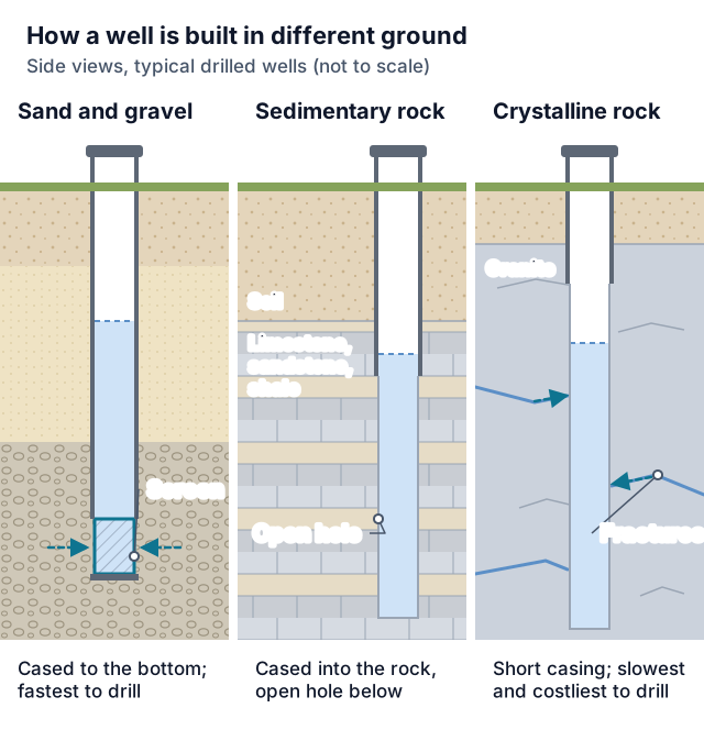
- Casing floor: under part 4725.4550, casing for a potable water-supply well must extend 15 feet or more beneath the established ground surface, and a gravel pack's top has to sit 15 or more feet down. Part 4725.0100 treats a well as sensitive when it has under 50 feet of watertight casing and that casing penetrates no confining layer, or set of confining layers, at least ten feet thick in total; sensitive wells must keep larger distances from many contamination sources.
- Drift thickness, not well depth: USGS Water-Supply Paper 2029-A (1973), covering about 1,400 square miles of the Mesabi Iron Range in St. Louis and Itasca Counties, found total drift thickness ranging from zero along the base of the Giants Range to 250 to 300 feet in two bedrock valleys and southeast of Grand Rapids, and more than 100 feet in most of the study area.
- Calculator: this site's cost calculator prices drilling as the depth you enter times a per-foot rate for the formation you pick, then adds a $200 to $500 permit line plus optional pump and pressure-tank lines. No published typical well depth for Itasca County turned up in this review, so this page shows no county total; use MDH's $325 as the permit figure and ask the driller for a written per-foot price.
Permits & Local Rules
- Notification: part 4725.1820 forbids constructing a water-supply well, deepening one through a confining layer, or putting in or pulling casing below the frost line before MDH receives notice. Filers can be a licensed well contractor, the property owner or the owner's agent, and for a drive-point well also a limited drive-point well or dug well/boring contractor; each well needs its own notification and fee, item B governs form and signatures, item D lists the contents, and a filing stays good for 18 months. If a different contractor builds the well, or it ends up on a different property, a new notification is filed without a second fee. Section 103I.205, subd. 1(a), does not require refiling after a failed attempt unless the successful well's information has substantially changed. A well that will need a DNR water appropriation permit also waits for the information listed in subd. 1(e) and the DNR's preliminary approval.
- Licenses: § 103I.205, subd. 4(a), requires a well contractor's license in possession to drill, construct, repair or seal a well or boring, apart from the license types and exemptions the subdivision and §§ 103I.401, subd. 2, and 103I.601, subd. 2, provide. Pump, pitless and screen work and sealing may instead be done under the matching limited well/boring contractor license (subd. 4(c); part 4725.0475, subps. 2 to 4 set the scope and the narrow exceptions). An individual who, at the direction and under the personal supervision of a licensed contractor, performs labor or services for a licensed contractor in connection with constructing, sealing or repairing a well or boring needs no license if the individual complies with the rest of chapter 103I (subd. 4(e)(2)); the owner exemption is in the FAQs.
- Pumps and repairs: part 4725.1837 exempts from notification and permits the installation of a pump, pumping equipment, a pitless unit or adapter, or a screen, and repairs to an existing well that neither deepen it through a confining layer nor involve installing or removing casing below the frost line. The license requirements above still cover that work.
- Owner drive-points: § 103I.205, subd. 1(d), lets an individual installing a drive-point water-supply well on property owned or leased by that individual, as the individual's place of abode or for farming or agricultural purposes, notify MDH afterward: the form is mailed no later than ten days after the well is completed, free of charge. Part 4725.1849 still holds the well to parts 4725.2010 to 4725.5650 and gives the individual no authority to seal it.
- Records: § 103I.205, subd. 7, has the builder attach a label showing the well's unique number. The statute gives whoever did the work 60 days from completion or sealing to file a verified report with MDH (subd. 9), but part 4725.1851, subp. 1, sets a 30-day deadline for an accurate, verified, legible written construction or sealing record, on forms the commissioner provides or in a format the commissioner approves, and drops the construction record when a well is sealed no more than 30 days after construction began and a sealing record is filed. Either record must name the contractor doing the work with its license or registration number and the driller performing the work, and must carry the signature of the certified representative (subp. 3, item B, which subp. 2 also applies to construction records). The licensee or registrant gives the owner or the owner's agent one copy, retains one and submits the remaining copies to the commissioner.
- First water sample: within 30 days of completion and before a new potable well is used, the person constructing it must see that a sample is collected and sent to a lab certified to analyze total coliform bacteria, nitrate-nitrogen and arsenic, and must tell the owner the water is not to be used for human consumption until results show total coliform absent and the nitrate-nitrogen and arsenic analyses are complete and reported. The rest of part 4725.5650 covers laboratory limits, reporting, coliform follow-up and when a pump job or repair needs a sample.
- Sealing: § 103I.301 puts sealing on the property owner when a well is contaminated or may contribute to the spread of contamination, when a previous sealing attempt fell short of chapter 103I, or when the way it is located, built or maintained makes its continued use or existence a threat to groundwater quality or a safety or health hazard. An unused well must either be sealed or be covered by the owner's maintenance permit. The sealer must be a licensed person with authority to seal that particular well, working after a sealing notification has been filed (subd. 6); part 4725.1832 keeps that notification valid for 18 months, and part 4725.3850 sets the sealing methods. Part 4725.3875, subp. 5, makes anyone who buries an unsealed, unused well, or puts a building over one, answerable for getting it sealed by a licensed or registered contractor.
- Keeping an unused well: the alternative to sealing is an annual MDH maintenance permit, applied for by the property owner with the $225 fee; part 4725.1848 sets what the application must contain and the conditions the permit carries.
- Distances: part 4725.4450 measures each minimum horizontally, from the nearest point of the casing's upper end to the nearest point of the source or of the source's vertical projection on the ground, whichever is closer. A source that is no longer used still counts unless its contaminants and any visibly contaminated soils have been removed. The part also bars placing, constructing or installing a contamination source closer to a water-supply well than the listed distances, which § 103I.205, subd. 6, allows only where a variance has been prescribed by rule, and it requires the well to sit where surface drainage is best, at the highest practical elevation and as far from contamination as practical. Subpart 2 doubles the distances between a sensitive well and a source directly entering the soil, and sets its own figures for the sources it lists. The FAQs give the septic and lake figures.
- Lakes and streams: part 4725.4350 sets 35 feet as the minimum horizontal distance between a water-supply well and the ordinary high water level of a stream, river, pond, stormwater retention pond or lake. That distance does not apply to an area protected by a flood control structure accepted by FEMA as designated on a FEMA flood map; to a wetland, grassed waterway, depression, culvert or ditch holding water less than six months of the year; or to an artificial pond holding less than 5,000 gallons.
- Flood areas: subpart 2 of the same part requires a well to be built to keep floodwater out by one of four construction methods it lists, except in an area protected by a FEMA-accepted flood control structure as designated on a FEMA flood map.
Geology & Water Table Notes
- Atlas status: the DNR's County Geologic Atlas series page, last changed September 18, 2026, shows Part A (geology) for Itasca County in progress and Part B (groundwater) as a future start. The Minnesota Geological Survey produces Part A (geology, sand distribution, bedrock topography, depth to bedrock); the DNR prepares Part B once Part A is done.
- Iron Range drift (1973): the USGS Water-Supply Paper 2029-A abstract calls the stratified fluvial sediments within the drift important aquifers that occur extensively between the three main till units, and the report says the major sand and gravel deposits generally lie between till units or at the surface. It named the Mississippi River and Pokegama Lake as potential recharge sources for groundwater development in the area near Grand Rapids.
- Neighboring logs: the Minnesota Geological Survey keeps the County Well Index in partnership with MDH; it covered more than 599,000 water wells and borings drilled in Minnesota (count as of June 2025), taken from well contractors' logs and later interpreted by MGS geologists. MDH's Minnesota Well Index gives basic information on wells and borings (location, depth, geology, construction, static water level) through a map or text search, warns that information from unverified wells should not be used for site-specific evaluations, and notes that missing information does not guarantee a property has no well.
- Arsenic: MDH says the way glaciers moved across Minnesota affects where arsenic is found in sediment and groundwater, and that a well's level cannot be known before it is drilled. Statewide, MDH reports arsenic was detected in about 40 percent of Minnesota's new wells drilled since 2008 and above 10 µg/L in about 10 percent of private wells, and highly recommends taking action above 10 µg/L. Since August 2008 contractors have tested each newly drilled well for arsenic and shared the result with the owner and MDH.
- Nitrate and manganese: MDH names shallow wells; wells in sand, karst and fractured rock aquifers; dug wells whose casings are not watertight; and wells with damaged or leaking casings or fittings as vulnerable to nitrate. Its manganese guidance is 100 µg/L or less where an infant drinks tap water or formula made with it, and 300 µg/L or less otherwise; an MDH study found southeastern Minnesota groundwater tends to be low in manganese and southwestern tends to be higher, with no clear pattern elsewhere in the state.
- Older wells: MDH lists wells built before 1974 (when the Minnesota Well Code was developed), dug wells with leaking walls and rotten board covers, wells at the bottom of old frost pits, wells with holes corroded through the casing, and wells too close to sewers, septic systems or animal feedlots as at higher risk of bacterial contamination, and advises talking with a licensed well contractor about the best option for such a well.
Communities Served
Grand Rapids · Cohasset · La Prairie · Deer River · Bigfork · Coleraine · Bovey · Taconite · Marble · Calumet · Nashwauk · Keewatin · Squaw Lake · Effie · Warba · Zemple
Emergency Response Expectations
Part 4725.1838 allows a water-supply well notification to be given verbally to MDH under emergency conditions, which it defines as exceptional circumstances in which prior notification is not possible in time and waiting to start construction would create a danger to health or safety that is immediate and significant; its examples include livestock or persons being left without drinking water because a well failed. The part has separate steps for business hours and after hours. The written notification and fee must arrive no more than five working days after the emergency notice that construction has started; the emergency notification becomes void if work has not begun in the 72 hours after the verbal report; the code's construction and location standards apply in full; and MDH may not accept emergency notifications from a contractor who has violated those emergency requirements. Read the part for who may report and who is responsible for the written follow-up. No arrival time can be promised through this site.
Itasca County FAQs
Does Itasca County issue its own well permits?
No. Itasca is not on MDH's list of delegated well programs, so the $325 construction notification goes to MDH, and § 103I.205, subd. 1(c), bars the county and its cities from requiring their own permit or notification for wells unless MDH has delegated that authority. Septic (SSTS) permits and zoning permits for the same lot come from Itasca County Environmental Services.
Can I construct my own water well without a license?
Section 103I.205, subd. 4(e)(1), exempts an individual who constructs a water-supply well on land that is owned or leased by the individual and used by the individual as the individual's place of abode or for farming or agricultural purposes, as long as the individual complies with the rest of chapter 103I. The exemption does not remove the notification and fee due before construction under subdivision 1(a) (an owner-installed drive-point well follows the after-the-fact, no-fee drive-point notice in the permit notes instead); part 4725.1851 still has the owner or lessee file the construction record, with the contents and signature that part requires, on the commissioner's form or in a format the commissioner approves, no later than 30 days after completing the work; the well code's construction and distance standards still apply; and § 103I.301, subd. 1(c), still requires a licensed person authorized to seal the well when it is sealed.
How far must a well be from the lake and the septic system?
At least 35 feet from the ordinary high water level of a lake, stream, river, pond or stormwater retention pond, apart from the exceptions in part 4725.4350 listed in the permit notes. Under part 4725.4450: 50 feet from a septic tank or a watertight sewage holding tank; 50 feet from a privy or from a soil dispersal system's absorption area averaging 10,000 gallons a day or less in design flow that does not serve a facility handling infectious or pathological wastes, or 100 feet for a sensitive well; cesspools, seepage pits, leaching pits and dry wells need 75 feet (150 for a sensitive well); and 50 feet from an unused, unsealed well. Sewers, sumps, larger systems and other sources have their own distances and conditions in that part.
What does a seller have to disclose about wells?
Under § 103I.235, before signing an agreement to sell or transfer the property, the seller must deliver a written disclosure to the buyer: either the seller's statement of not knowing of any wells on the property, or a disclosure statement giving the legal description and county, a map drawn from available information showing where each well is to the extent practicable, and marking each well as in use, not in use or sealed. When the sale closes, those details go on a well disclosure certificate along with the other items paragraph (b) lists, and the county recorder charges a $54 fee for it to the buyer or whoever seeks to record the deed. The statute also sets exceptions (for example, a no-known-wells statement on the deed) and the seller's liability for an undisclosed well; MDH's Well Disclosure page explains the process and says the law covers drive-point (sand-point), drilled and dug wells.
Which water tests does MDH recommend for a private well?
MDH's list: coliform bacteria every year and whenever the well or water system has been worked on or the water tastes, smells or looks different; nitrate every year, plus whenever someone is planning a pregnancy or infants will be using the water; arsenic at least once, with MDH's arsenic page asking for at least one test beyond the first one taken when the well is built; and lead and manganese once each at a minimum. MDH suggests an accredited lab, or checking whether your county environmental or public health services test well water, and notes it may suggest other tests depending on location. If a new well's sample showed arsenic, MDH notes that owners may want to retest roughly six months after construction.
What should I do if a coliform test comes back positive?
MDH's steps: use boiled or bottled water, or water from another safe source, for drinking and cooking until the problem is addressed (if nitrate or arsenic was also found, boiling may not be the safest option because it can concentrate them); disinfect the well with a chlorine solution, through a licensed well contractor or by following the instructions on MDH's well disinfection page; test again after disinfection; and use the water again without boiling once the well has been disinfected and no longer tests positive. If disinfection attempts keep failing, MDH says to work with a licensed well contractor, and that bailing debris out of the well or building a new well may be needed.
Is there a typical well depth for Itasca County?
Not in any agency source found for this review. The 1973 USGS Mesabi Range report gives drift thicknesses, not well depths, and the county's geologic atlas is unfinished, so ask a driller to pull logs of nearby wells from the Minnesota Well Index. Whatever the depth, part 4725.4550 sets 15 feet of casing as the minimum for a potable well.
Sources
- Minn. Stat. § 103I.205 (well construction)
- Minn. Stat. § 103I.208 (fees)
- Minn. Stat. § 103I.235 (well disclosure at sale)
- Minn. Stat. § 103I.301 (sealing)
- Minn. Stat. § 103I.111 (local delegation)
- Minn. R. 4725.0100 (definitions)
- Minn. R. 4725.0475 (licensing)
- Minn. R. 4725.1820 (construction notification)
- Minn. R. 4725.1832 (sealing notification)
- Minn. R. 4725.1837 (pump and repair exception)
- Minn. R. 4725.1838 (emergency notification)
- Minn. R. 4725.1848 (maintenance permits)
- Minn. R. 4725.1849 (owner drive-point wells)
- Minn. R. 4725.1851 (well records)
- Minn. R. 4725.3850 (sealing methods)
- Minn. R. 4725.3875 (responsibility for sealing)
- Minn. R. 4725.4350 (water bodies and flood areas)
- Minn. R. 4725.4450 (isolation distances)
- Minn. R. 4725.4550 (minimum casing depth)
- Minn. R. 4725.5650 (new-well water sample)
- MDH: Well Management fee schedule (effective July 1, 2025)
- MDH: Delegated Well Programs (last updated March 12, 2025)
- MDH: Owner's Guide to Wells
- MDH: Bacterial Safety of Well Water
- MDH: Arsenic in Well Water
- MDH: Nitrate in Well Water
- MDH: Manganese in Drinking Water
- MDH: Well Disclosure and Property Transfers
- MDH: Sealing of Wells and Borings
- MDH: Minnesota Well Index
- Minnesota Geological Survey: County Well Index
- Minnesota DNR: County Geologic Atlas series (Itasca County status)
- USGS Water-Supply Paper 2029-A (1973), Mesabi Iron Range drift
- USGS WSP 2029-A report (PDF)
- Itasca County: Environmental Services
- Itasca County Environmental Services: Septic Systems
- Census Bureau: 2020 places by county, Minnesota
Last reviewed 2026-10-30
Nearby Counties
Services Available in Itasca County
Well Drilling
New residential wells — find local drillers for site evaluation, depth estimates, and written drilling quotes.
Learn more →Water Well Drilling
Household water wells from site evaluation through casing, pump, and water test — written quotes from local drillers.
Learn more →Well Pump Repair
No water at the tap? Request urgent well pump repair — local pros diagnose pressure loss, dead pumps, and pressure tank failures fast.
Learn more →Well Pump Replacement
Pump at end of life or beyond repair? Get quotes for correctly-sized submersible and jet pump replacement from local well pros.
Learn more →Well Inspection & Testing
Buying a home with a well, or overdue for a water test? Local pros for flow tests, equipment inspection, and lab water-quality testing.
Learn more →Well Water Service
Water quality problems, treatment systems, and general well maintenance — connect with local pros for everything between drilling and pump work.
Learn more →Free Tools Before You Call
Ballpark the cost or narrow down the problem before talking to an Itasca County provider.
Well Drilling Cost Calculator
Estimate what drilling a well should cost — by depth, geology, and whether you need the pump and pressure tank included.
Use the free tool →No Water From Your Well? Diagnostic Wizard
Suddenly no water in the house? Answer a few questions to find out if it's the breaker, the pressure switch, the tank, the pump — or the well itself.
Use the free tool →Well Pump Size Calculator
Find what size well pump you need — GPM demand, total dynamic head, and a horsepower recommendation from four quick inputs.
Use the free tool →Need help in Itasca County, MN?
Send the short form — urgent requests get priority routing.